High Barnet is a historic market town in North London with roots that predate the Norman Conquest. Its development was shaped by a medieval market charter, the Great North Road, coaching traffic, the Battle of Barnet in 1471, railways, suburban expansion and its continuing role as a town centre.
- When was High Barnet first established?
- Why did a settlement develop at High Barnet?
- How did Barnet Market shape the history of High Barnet?
- What happened to High Barnet during the Battle of Barnet?
- Why is St John the Baptist Church important to High Barnet’s history?
- How did the Great North Road influence High Barnet?
- When did the railway arrive in High Barnet?
- How did High Barnet change during the Victorian period?
- How did the 20th century transform High Barnet?
- Why is High Barnet sometimes called Chipping Barnet?
- What historic buildings and places can visitors see in High Barnet?
- How can visitors research the history of High Barnet today?
- How did High Barnet become part of London?
- What is the historical significance of High Barnet today?
- What is the overall history of High Barnet?
Today, High Barnet sits within the London Borough of Barnet, close to the Hertfordshire boundary. The name is used interchangeably with Chipping Barnet in many historical and modern contexts. Barnet Council describes High Barnet as the oldest town in the borough and identifies the historic market as a defining feature of its development.
The history of High Barnet is therefore not the history of a single foundation date. It is the story of a settlement that developed around a strategic route, became an important medieval market town, gained national historical significance through the Wars of the Roses and later transformed into a connected London suburb.
When was High Barnet first established?
High Barnet developed as a settlement during the medieval period, although the wider Barnet area has earlier origins. Its town grew around a major northbound route and market activity, while archaeological evidence for a Roman settlement remains limited and does not establish a Roman foundation.
Barnet Council states that Barnet existed before the Norman Conquest but did not appear in the Domesday Survey of 1086. East Barnet represents the older settlement area, while the settlement that became High Barnet developed around an important route running north from London towards St Albans.
The physical location was important. High Barnet occupies elevated ground on the historic route between London and northern England. The settlement formed around a fork in the road where the present High Street meets Wood Street. This road structure helped create the town’s commercial centre.
There is discussion of possible Roman activity in the area. Barnet Council records the possibility of a Roman settlement at High Barnet but states that evidence remains limited. The stronger historical evidence begins with the medieval development of the town and its market.
The name Barnet is associated with an Old English term connected with a clearing. Barnet Council’s heritage material explains that “baernet” refers to a clearing in a forest created by burning. This reflects the landscape transformation that occurred as woodland was cleared for agriculture, settlement and transport.
High Barnet therefore developed from a combination of geography and economic activity rather than from one documented act of foundation.
Why did a settlement develop at High Barnet?
High Barnet developed because it occupied a strategically important ridge beside a northbound route from London. Road traffic, access to surrounding agricultural land and the creation of a permanent market transformed the location from a roadside settlement into an important medieval commercial centre.
The historic Great North Road was central to High Barnet’s development. The route connected London with destinations farther north and passed through Chipping Barnet, Hadley Green and Hadley Highstone before continuing towards Potters Bar and beyond.
This position gave High Barnet a practical commercial advantage. Travellers required food, accommodation, fresh horses and other services. Traders required somewhere to exchange livestock and goods. Local agricultural communities required a regular market.
The settlement’s elevated position also influenced its later importance as a coaching centre. Barnet Council records that the town’s position at the top of the hill contributed to its role as a major stopping point for coaches. By 1756, the town had 25 inns where coaches could change horses.
This development created a clear relationship between transport and commerce. Roads brought people into High Barnet. The market provided an economic reason to stop. Inns supported travellers. Shops and services developed around the resulting footfall.
The same geographical advantage later helped rail transport transform the town. High Barnet’s history therefore demonstrates a continuous pattern: the town grew whenever a major transport system increased its connection with London and the wider region.
How did Barnet Market shape the history of High Barnet?
Barnet Market was fundamental to High Barnet’s development. King John granted a weekly market charter in August 1199, creating an established commercial institution that strengthened the town’s economy and helped give Chipping Barnet its distinctive market-town identity.
The 1199 charter is one of the most important dates in High Barnet’s history. King John granted the Lord of the Manor permission to hold a weekly market. Barnet Council records that the market had already existed in some form since at least the 12th century and that livestock trading probably preceded the formal charter.
The term “Chipping” is directly associated with this market function. It derives from an Old English word connected with trade or a market. Chipping Barnet therefore means a market-associated Barnet.
The market was not always located exactly where visitors find it today. The historic market was originally situated around the point where Wood Street divides from the High Street. Its location and form changed over time.
By the Tudor period, Barnet had become particularly important for the livestock and meat trade. Barnet Council records that, by the late Tudor period, the market controlled much of London’s meat supply. London butchers travelled to Barnet to buy cattle, while animals were kept on nearby farms before being taken into London as required.
A second market charter was issued by Queen Elizabeth I in 1588. By the end of the 16th century, Barnet had become London’s main meat market before the expansion of Smithfield’s dominance.
The market later declined in importance as competing markets expanded. By the 1830s, the market was described as insignificant compared with its earlier importance, and market activity contributed to congestion on the main road.
Despite these changes, the market survived as a defining feature of High Barnet. Barnet Council states that Barnet Market, which began in 1199, continues today.

What happened to High Barnet during the Battle of Barnet?
The Battle of Barnet took place on 14 April 1471 during the Wars of the Roses. The battle occurred north of High Barnet and resulted in the death of Richard Neville, Earl of Warwick, strengthening Edward IV’s position in the struggle between York and Lancaster.
The Battle of Barnet was one of the most significant events connected with the history of High Barnet. It formed part of the Wars of the Roses, a prolonged conflict between the Houses of Lancaster and York over the English throne.
The battlefield lies north of High Barnet. Historic England identifies the registered battlefield across areas associated with Barnet, Hertfordshire and Greater London.
The conflict involved Edward IV of the House of York and Richard Neville, Earl of Warwick, known as the Kingmaker. Warwick had previously supported Edward but later backed the Lancastrian cause and helped restore Henry VI.
Edward returned to England in 1471 and advanced towards London. Warwick moved to intercept him. The armies met near Barnet on 14 April 1471.
Historic England records that the battle was fought approximately ten miles north of London and that the high ground near High or Chipping Barnet influenced the choice of battlefield.
The battle produced a decisive Yorkist victory. Warwick was killed, weakening the Lancastrian cause and removing one of the most powerful political figures of the period.
The battlefield is not simply an isolated historical site. Its location reflects the importance of High Barnet’s geography. The same high ground that supported the town’s position along the northbound road also contributed to its military significance.
Visitors interested in the battle can therefore understand High Barnet’s history by considering the relationship between the town centre, the historic road and the surrounding northern landscape.
Why is St John the Baptist Church important to High Barnet’s history?
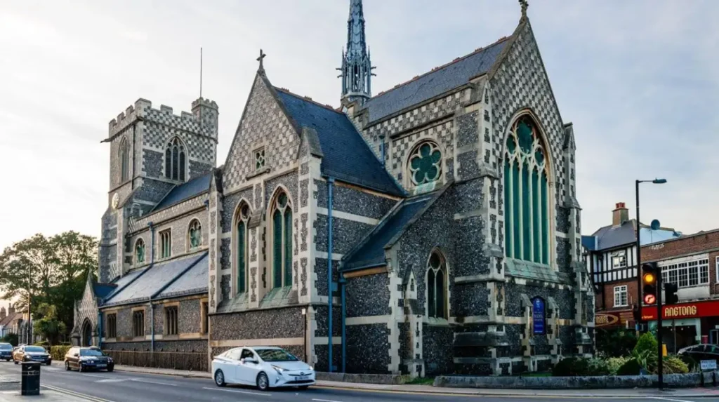
St John the Baptist Church stands at a historic junction in High Barnet and reflects the town’s medieval religious development. The present building is largely the result of a major Victorian reconstruction, while the site itself has hosted churches since the medieval period.
St John the Baptist Church occupies the junction where Wood Street meets the High Street. This location is important because the junction represents the historic centre around which the town developed.
Barnet Council records that the first church on the site was built in the 11th century. A second church was constructed in the middle of the 15th century using money left by John Beauchamp.
The current church largely dates from a major rebuilding project completed in 1875. Architect William Butterfield designed the reconstruction at a cost of £16,000. The north aisle remains from the 15th-century church.
The church therefore represents several phases of High Barnet’s history. The medieval building reflects the town’s growth before the modern period. The Victorian reconstruction reflects the population and economic changes that accompanied 19th-century urban development.
The church’s location also illustrates the relationship between religious institutions and historic town centres. Medieval markets, churches, inns and major roads frequently occupied interconnected spaces.
For visitors exploring High Barnet today, St John the Baptist Church provides a direct physical link between the modern High Street and the medieval settlement.
How did the Great North Road influence High Barnet?
The Great North Road made High Barnet a major transport settlement between London and northern England. Coaching, livestock movement, trade and passenger traffic supported inns and businesses, turning the town’s elevated location into a major economic advantage.
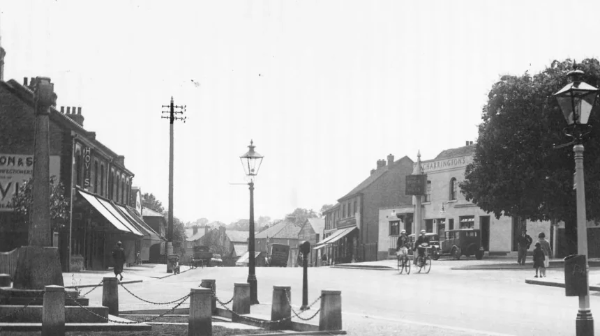
The Great North Road was one of the defining transport corridors in High Barnet’s history. It linked London with towns and cities farther north and passed directly through the settlement.
The road encouraged the development of inns and coaching services. High Barnet’s position on a hill made it a natural stopping point for coaches travelling north.
By 1756, Barnet had 25 inns serving the coaching trade. These establishments provided accommodation, food and fresh horses. Their concentration demonstrates the scale of transport activity in the town.
The road also influenced the physical shape of High Barnet. Commercial premises developed along the High Street because businesses benefited from passing traffic.
The route eventually became difficult for increasing traffic. Between 1818 and 1823, the road was improved and the steep incline was reduced by constructing a raised causeway from Underhill. In 1828, another road was created towards St Albans, providing a shorter route.
The coaching economy subsequently declined as railways offered faster connections. The toll on the turnpike road was removed in 1862, marking another stage in the changing transport system.
The historical importance of the Great North Road remains visible in the layout of High Barnet. The modern High Street follows the logic of an older transport corridor.
As you explore the modern site, you are crossing land with a deep heritage. Read about the full [Insert Anchor Text for History Article Here] to understand its origins.
When did the railway arrive in High Barnet?
Railway development transformed High Barnet during the 19th century. The Great Northern Railway opened the High Barnet branch in 1872, strengthening connections with London and encouraging residential development that gradually changed the town from a coaching centre into a commuter settlement.
Railway development marked a major turning point. Barnet already had a station from 1850, later known as New Barnet. The High Barnet branch followed in 1872.
High Barnet station became an important connection between the town and London. The arrival of rail transport reduced the town’s dependence on long-distance coaches.
Railways also changed where people lived. New residential streets developed around railway-connected areas, although expensive fares initially restricted the pace of suburban expansion.
Barnet Council records that New Barnet, High Barnet, and Totteridge and Whetstone stations contributed to suburban road development during the late 19th century. Areas such as Brunswick Park also developed during this period.
The railway therefore had two major effects. It changed transport patterns and encouraged population growth.
High Barnet’s relationship with the railway also explains the continued use of the name “High Barnet”. Barnet Council records that the name is Elizabethan and predates the railway, although the Great Northern Railway’s use of High Barnet station helped establish the name in modern transport usage.
The branch eventually became part of the Underground network. High Barnet is now served by the Northern line, giving the historic market town a direct rapid-transit connection with central London.
How did High Barnet change during the Victorian period?
Victorian High Barnet experienced substantial physical and social development. New streets, churches, schools, businesses and public institutions appeared as transport connections improved, while the historic High Street remained the commercial centre of the growing town.
The 19th century brought significant changes to the built environment.
New streets were laid out during the 1820s and 1830s. Moxon Street was described as new in 1825, while Union Street was built in 1837. The expansion created additional space for housing and community facilities.
Christ Church was built on St Albans Road in 1845. Its construction reflected the expanding population and the development of new residential areas beyond the historic centre.
By 1881, streets including Salisbury Road, Strafford Road, Alston Road and Stapylton Road had been laid out. This street expansion created the framework for the more extensive suburban development that followed.
High Barnet also developed new educational and civic institutions. Queen Elizabeth’s School for Girls was founded in 1888 and is identified by Barnet Council as an early girls’ school in Hertfordshire.
Commercial activity also diversified. John James Cowing established a printing company on the High Street in 1805. His sons later established the Barnet Press newspaper in 1859.
These developments demonstrate that Victorian High Barnet was no longer simply a market and coaching settlement. It had developed into a more complex urban community with education, publishing, retail, religious institutions and transport.
How did the 20th century transform High Barnet?
The 20th century transformed High Barnet through improved public transport, suburban housing and changing retail patterns. Tram services, railway electrification and Underground development connected the town more closely with London and supported continued residential expansion.
Public transport became increasingly important during the early 20th century. Barnet Council records that a tramline from Archway reached the area in March 1907.
This development strengthened High Barnet’s connection with the wider London transport system. Improved accessibility encouraged residential growth and reduced dependence on the historic coaching road.
The railway was later integrated into the London Underground network. High Barnet became part of the Northern line, giving residents direct access towards central London.
The 20th century also brought changes to the town centre. Traditional inns and coaching businesses declined as motor vehicles replaced horse-drawn coaches. Retail businesses adapted to changing consumer habits.
Entertainment also became part of High Barnet’s modern commercial identity. The Cinema Palace opened on the High Street in 1912 and became Barnet Cinema in 1926. It closed in 1959 and the site was later replaced by a supermarket.
The Spires shopping centre opened in 1989. It occupies a site associated with earlier Methodist and military uses, demonstrating how modern retail development reused historically significant urban land. Chipping Barnet Library opened in 1991.
High Barnet therefore retained its historic centre while adapting to modern retail, transport and residential requirements.
Why is High Barnet sometimes called Chipping Barnet?
High Barnet and Chipping Barnet refer to the same historic town in many modern contexts. “Chipping” reflects the town’s medieval market identity, while “High Barnet” became increasingly prominent as a geographical and transport name. Both names remain established.
The distinction between the names often causes confusion for visitors.
“Chipping” refers to the market. The word derives from an Old English term associated with trade and markets. Chipping Barnet therefore describes Barnet as a market town.
“High Barnet” describes the settlement’s position and became increasingly common over time. Barnet Council records examples of the name dating from the 16th and 17th centuries, demonstrating that it did not originate solely with the railway.
The Great Northern Railway’s High Barnet station reinforced the modern use of the name. The railway already had New Barnet on the main line, so “High Barnet” provided a clear distinction.
Today, Barnet Council describes Chipping Barnet as also being known as High Barnet. Chipping Barnet is also used for the parliamentary constituency, while High Barnet is used for the local authority ward.
For historical research, both names are therefore relevant search terms.
What historic buildings and places can visitors see in High Barnet?
Visitors can explore historic streets, St John the Baptist Church, Barnet Market, the High Street and nearby Monken Hadley. Together, these places reveal High Barnet’s medieval market origins, coaching history, religious development, suburban expansion and connection with the Great North Road.
The High Street remains the principal place to understand the town’s historical development. Its alignment reflects the older northbound route.
St John the Baptist Church provides evidence of medieval religious continuity. Barnet Market represents the commercial tradition established formally by the 1199 charter.
Nearby Monken Hadley provides additional historical context. The conservation area retains connections with the historic Great North Road and contains Hadley Green and Hadley Highstone.
The wider area also contains evidence of changing land use. A site near the High Street that later became associated with the Territorial Army was used as a plant nursery from 1729 to 1937. The nursery was originally operated by the Emmerton family and later by the Cutbush family.
Modern visitors can therefore identify several layers of High Barnet’s history within a relatively compact area.
The town centre also contains modern facilities alongside historic buildings. Barnet Council identifies Barnet Market, the Spires Shopping Centre, Chipping Barnet Library, independent businesses, restaurants, cafés and bars as current features of the centre.
This combination makes High Barnet useful for heritage-focused visits without requiring travel across a large geographical area.
How can visitors research the history of High Barnet today?
Visitors can research High Barnet’s past through Barnet Council’s Local Studies and Archives, historic maps, photographs, newspapers, planning documents, museum collections and heritage records. These resources provide evidence for researching buildings, streets, families, businesses and historical events.
Barnet Council’s Local Studies and Archives service holds historical documents dating from 1600, including maps, newspapers, photographs, publications and archival material. Many resources are available digitally.
The council also maintains a substantial digital collection containing historical documents, books, pictures and maps relating to Barnet and other parts of the borough.
Barnet Museum is another useful resource for understanding the area’s past. Barnet Council identifies the museum as an important heritage institution displaying material connected with local history, including medieval events and cultural development.
Historic England provides another authoritative source for understanding protected heritage and the Battle of Barnet battlefield. Its National Heritage List includes the registered battlefield and other historic sites associated with the wider Barnet area.
These resources are particularly valuable because High Barnet’s history involves several administrative boundaries and names. Historical records can refer to Barnet, Chipping Barnet, High Barnet, Hertfordshire, Middlesex or later London government structures.
Using multiple authoritative sources therefore produces a more accurate picture than relying on one modern place name.
How did High Barnet become part of London?
High Barnet became part of Greater London through 20th-century local government reorganisation. The London Borough of Barnet was created in 1965, bringing historic communities including Barnet into the administrative structure of Greater London.
Local government boundaries changed significantly during the 20th century.
Before modern London government, different parts of the Barnet area were administered through separate authorities. Barnet Council records that local government in Barnet town was divided among several authorities, including the civil parishes of Chipping Barnet, South Mimms and Hadley during earlier periods.
Monken Hadley provides a clear example of changing administrative geography. It was originally part of Middlesex, later formed part of East Barnet District in Hertfordshire between 1895 and 1965, and is now within the London Borough of Barnet.
The creation of the London Borough of Barnet in 1965 placed High Barnet within Greater London.
This change did not erase the town’s older identity. The historic market, High Street, church, road network and surrounding conservation areas continued to express the earlier history.
High Barnet therefore combines medieval market-town heritage with a modern London administrative identity.
Explore More Area Guide
When Was Barnet First Established? History Guide
Best Connected Barnet Areas to Central London, North London 2026
What is the historical significance of High Barnet today?
High Barnet remains historically significant because its modern town centre preserves evidence of medieval commerce, the Great North Road, the 1471 Battle of Barnet, coaching transport, Victorian expansion, railway development and London’s suburban growth within one connected urban landscape.
High Barnet’s historical significance comes from continuity rather than a single monument.
The 1199 market charter established an economic tradition that continues through Barnet Market. The Great North Road established the town as an important transport settlement. The Battle of Barnet connected the location with one of England’s major dynastic conflicts.
The coaching era left evidence in the historic High Street and former inn locations. Victorian expansion introduced new roads, churches, schools and commercial businesses. Railways then connected High Barnet more closely with London.
The Underground strengthened that relationship and helped establish the town as part of North London’s suburban transport network.
The result is a layered historic environment. Medieval, early modern, Georgian, Victorian, Edwardian and modern developments exist within the same town.
For tourists, this makes High Barnet more than a conventional North London shopping district. Its streets provide a route through different periods of English urban development.
For residents, local researchers and visitors interested in heritage, the town offers a concentrated example of how transport, markets, politics, religion and suburbanisation shaped a settlement over many centuries.
What is the overall history of High Barnet?
High Barnet developed from a medieval settlement beside a major northbound road into a market town, coaching centre and London suburb. Its defining milestones include the 1199 market charter, the 1471 battle, railway expansion, Underground connectivity and modern town-centre development.
The history of High Barnet begins with its geographical position. The settlement developed on high ground beside a major route from London towards the north.
Its medieval market gave the town an enduring economic purpose. The 1199 charter formalised weekly market activity and established the commercial identity represented by the name Chipping Barnet.
The town then gained national historical significance in 1471 when the Battle of Barnet took place nearby during the Wars of the Roses.
During the 18th century, the Great North Road and coaching trade made High Barnet an important stopping point. Twenty-five inns were recorded in 1756, demonstrating the scale of transport-related activity.
Road improvements followed during the early 19th century. Railways then changed the transport economy, with High Barnet’s branch opening in 1872.
The Victorian period brought new streets, churches, schools and businesses. The 20th century brought tram services, Underground integration, suburban housing and modern retail.
Today, High Barnet retains its historic market identity while functioning as a London town centre. Its history remains visible in the High Street, market, church, road layout, nearby battlefield and surrounding heritage areas.
Understanding High Barnet therefore requires understanding how market, road, battle, railway and suburb interacted over time. These forces explain why the town developed where it did and why it remains an important historic centre in North London.
When was High Barnet first established?
High Barnet developed as a medieval settlement, although the wider Barnet area has earlier origins. Its growth centred on a major northbound route and market activity. The formal market charter granted by King John in 1199 became a defining milestone in the town’s development.