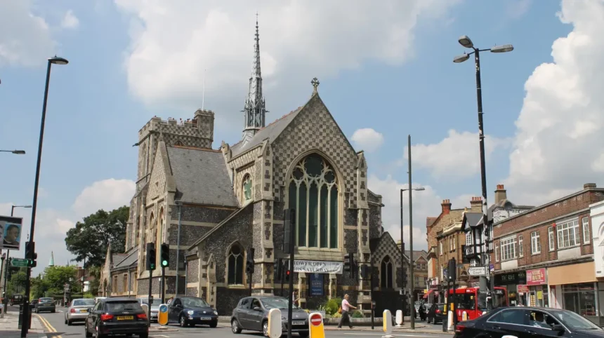
Barnet’s transformation from a medieval market settlement into the modern London Borough of Barnet took centuries. Roads, markets, railways, suburban housing, local government reforms and London’s 1965 administrative reorganisation gradually reshaped the area.
- How did medieval Barnet become a market town?
- Why did Barnet become an important stopping point between London and St Albans?
- How did Barnet Market influence the town’s economy?
- How did Barnet Fair contribute to the town’s development?
- How did railways change Barnet from a market town into a suburb?
- How did public transport accelerate Barnet’s suburban growth?
- How did housing development reshape Barnet during the 19th and 20th centuries?
- How did Barnet’s population growth demonstrate its transformation?
- Why were Barnet, East Barnet, Finchley, Friern Barnet and Hendon governed separately?
- Why was the London Borough of Barnet created in 1965?
- How did the 1965 borough combine different communities?
- How did Barnet’s urban development affect its relationship with London?
- How did planning protect parts of Barnet from continuous urban expansion?
- What is Barnet today compared with the original market town?
- Why is Barnet’s transformation from market town to London borough historically important?
The name Barnet describes both a historic settlement and a much larger modern London borough. This distinction is important when tracing its development. High Barnet grew around a medieval market and a major northbound route. The modern borough incorporates High Barnet alongside Hendon, Finchley, East Barnet, Friern Barnet, Edgware, Mill Hill, Golders Green and other districts.
The transformation was therefore not simply the expansion of one town. It was the administrative combination of several settlements that had developed independently under different authorities.
The story begins with geography. Barnet stood on a major route between London and St Albans. By the 11th century, an important route north from London passed through the area, creating the conditions for a settlement to grow.
How did medieval Barnet become a market town?
Barnet became a market town because its position on an important northbound route connected London with communities beyond the capital, while royal market rights encouraged regular commercial activity. The market developed into a major livestock centre and established Barnet as a regional trading settlement.
High Barnet developed around the junction associated with Wood Street and the church of St John the Baptist. Barnet Council identifies the market as existing in various forms and locations since at least the 12th century. There is also evidence that a livestock market existed before King John granted a charter in August 1199.
A market charter was a formal grant permitting regular commercial activity. In medieval England, such rights were economically important because markets concentrated trade, attracted travellers and supported local services.
Barnet’s market was closely linked to livestock. Cattle moved through the settlement because London required large quantities of meat. By the late Tudor period, Barnet’s market controlled the sale of nearly all London’s meat according to the borough’s historical records. London butchers travelled north to purchase cattle, while animals were kept on nearby farms before being brought into London.
The market also influenced the physical structure of the town. Shops, inns and service businesses developed around the main route. Barnet High Street subsequently became the principal shopping area and has served that role since at least the 18th century.
Barnet’s commercial importance also produced a strong visitor economy. Inns served travellers using the northbound road, while fairs created additional trading and entertainment activity.

Why did Barnet become an important stopping point between London and St Albans?
Barnet became an important stopping point because its hilltop position placed it directly on the northbound road from London. Coaches, traders and livestock traffic created demand for inns, markets, shops and services, turning the settlement into a significant transport and commercial centre.
The road network was fundamental to Barnet’s early growth. The settlement developed where a major route north from London crossed the area. Its elevated position made it a natural stopping point for travellers.
The road later became associated with the Great North Road. In 1712, the High Road was converted into a turnpike. A turnpike road was a route where travellers paid a toll towards maintenance and improvement.
Barnet’s coaching economy became particularly prominent during the 18th century. By 1756, the town had 25 inns where coaches could change horses. This number demonstrates how strongly transport influenced the local economy.
Road improvements continued during the early 19th century. Between 1818 and 1823, the main road was improved and the steep incline was reduced through engineering works. In 1828, another road created a shorter route towards St Albans.
The coaching system eventually declined. The toll on the main road was removed in 1862, while railways increasingly provided faster long-distance transport.
This transition was crucial. Barnet did not lose its importance when transport technology changed. Instead, railway infrastructure created a new phase of development.
How did Barnet Market influence the town’s economy?
Barnet Market supported the town’s economy by concentrating livestock trading, food supply, retail activity and visitor traffic. Its importance changed over time as London developed competing markets, but the market remained a defining feature of Barnet’s commercial identity.
Barnet Market changed location and function several times. The original market was near the junction where Wood Street divides from the High Street. Historical records state that it was held on Mondays in 1588 and on Wednesdays by the 18th century.
The market’s livestock function was particularly important. Barnet became part of the supply chain serving London’s rapidly expanding population.
By the end of the 17th century, however, competition reduced its original dominance. Smithfield Market in London and Hog Market in Finchley provided alternative outlets for livestock and meat.
The market subsequently faced physical pressures from increasing road traffic. By the 1830s it was described as an obstruction to coaches. The congestion around St John’s Church became known locally as “the squeeze”.
The cattle market moved to New Road in 1851 and closed during the following decade. A market was re-established near the Green Man inn in 1869. The final cattle auction in the main market took place in August 1959. The market then became increasingly general in character.
This change reflects Barnet’s wider transformation from an agricultural trading centre into a suburban commercial district.
How did Barnet Fair contribute to the town’s development?
Barnet Fair strengthened the town’s regional importance by attracting traders, livestock buyers, travellers and spectators. Established in 1588, the fair became a major annual event and reinforced Barnet’s commercial connection with London and surrounding communities.
Barnet Fair began in 1588 as a horse and pleasure fair. Cattle were also sold, and the event eventually became an important regional attraction.
The fair was connected with horse racing, boxing and other sporting activities. Large numbers of visitors travelled from London and surrounding districts.
Historical records state that approximately 40,000 cows were bought and sold at the fair during the 19th century. That figure demonstrates the scale of livestock commerce associated with Barnet.
The arrival of the railway changed the fair’s physical environment. Horse racing took place on land that later became associated with the railway station. The construction of the railway ended serious horse racing at the site.
The decline of horse transport during the 20th century reduced the fair’s wider economic significance. Its survival nevertheless demonstrates the continuing importance of Barnet’s market-town heritage.
How did railways change Barnet from a market town into a suburb?
Railways changed Barnet by reducing travel times to London, opening land for housing and encouraging new residential districts. Stations at Barnet, New Barnet and High Barnet connected existing settlements with metropolitan London and accelerated suburban development.
Railway development was one of the most important turning points in Barnet’s urban history.
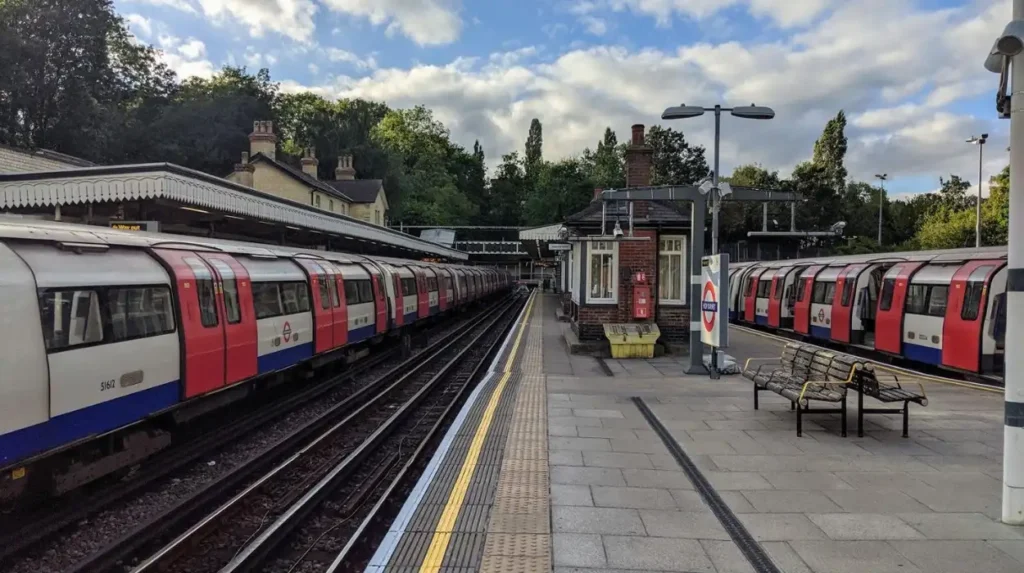
Barnet Station opened in 1850 and later became known as New Barnet Station. High Barnet and Totteridge and Whetstone stations opened in 1872. These stations encouraged suburban road development, particularly around New Barnet and Brunswick Park.
New Barnet provides a particularly clear example of railway-led urbanisation. Before the railway arrived, New Barnet did not exist as a developed settlement. The railway company acquired land from farms and estates, including the Lyonsdown estate. The British Land Company subsequently developed the surrounding land for housing.
Housing development began along roads including New Barnet Road, Lyonsdown Road and Station Road. By 1857, houses were already being marketed on New Barnet Road. Development continued for decades and was substantially built out by the First World War.
Railways therefore changed the economic geography of Barnet. The town no longer depended primarily on livestock, coaching and agricultural trade. It increasingly became a residential location for people working elsewhere.
How did public transport accelerate Barnet’s suburban growth?
Public transport accelerated Barnet’s suburbanisation by making daily travel between northern settlements and central London more practical. Railways, trams and underground services opened new residential areas and reduced the economic isolation of districts that had previously remained rural.
Railways started the process, but later public transport greatly increased its scale.
Barnet Council records that railway fares initially remained expensive. As a result, areas such as East Barnet, Arkley and Mays Lane retained rural characteristics even after railway stations appeared.
A major change came in March 1907 with tram services from Archway. The railway network was later integrated into London’s Underground system. These transport improvements encouraged much more extensive suburban street development.
The wider Finchley and Friern Barnet area experienced a similar transformation. The Great Northern Railway opened a station at Colney Hatch, now New Southgate, in 1851. A railway line reached Finchley in 1867 and a branch to Barnet opened in 1872. Trams began operating in Finchley in 1905.
The Northern Line connection further strengthened London’s influence. The Great Northern Railway line became part of London Transport’s Northern Line in 1939, with an Underground link to Archway opening in 1940.
This transport network transformed Barnet from a collection of market, agricultural and village settlements into an interconnected suburban area.
How did housing development reshape Barnet during the 19th and 20th centuries?
Housing development reshaped Barnet by replacing agricultural land around transport corridors with residential streets, shops and community facilities. Railway access, tram services and road improvements created the infrastructure that supported large-scale suburban expansion across northern Barnet.
Suburban growth was uneven. Areas closest to railway and tram connections generally urbanised earlier, while locations farther from transport remained rural for longer.
New Barnet provides a clear example of planned residential development. The railway company and private developers created streets and housing estates around the new station. Victorian street names in the area also preserved connections with Barnet’s medieval history, including references associated with the Battle of Barnet.
Finchley followed a similar pattern. After enclosure, North Finchley began developing during the 1820s. The Finchley Road was constructed in the late 1820s, linking Marylebone with the Great North Road at Tally Ho Corner. Horse-drawn omnibuses were already carrying commuters towards London by 1827.
Hendon also experienced substantial change. Although its earlier economy included woodland, agriculture and hay production, Hendon developed into a town after the 1860s.
Industrial activity also became part of the suburban landscape. Finchley had motor manufacturing, while Friern Barnet developed factories from the 1890s. Simms Motor Units at Red Lion Hill eventually employed more than 2,000 people at its peak.
Barnet therefore developed as more than a dormitory suburb. Housing, manufacturing, retail, transport and public services all contributed to its urban structure.
How did Barnet’s population growth demonstrate its transformation?
Population growth shows how rapidly Barnet changed from scattered rural settlements into an urbanised area. Barnet Town grew from 8,367 people in 1901 to 20,677 in 1961, while East Barnet reached 35,962 by 1961.
Historical population comparisons must be treated carefully because Barnet’s boundaries changed frequently. Barnet Council states that consistent population figures are generally available only for the period from 1901 to 1961.
Barnet Town illustrates the scale of change particularly clearly. Its population increased from 8,367 in 1901 to 10,440 in 1911, 13,702 in 1931, 19,841 in 1951 and 20,677 in 1961.
New Barnet also expanded substantially. Its population reached 6,535 in 1911, 8,331 in 1921 and 11,309 in 1931. By 1951, it had reached 15,634.
Arkley demonstrates the contrast between urban and rural development. Its population remained only 491 in 1891 and 494 in 1911, before increasing to 1,929 in 1931 and 8,711 in 1961.
These figures demonstrate that urbanisation occurred in stages rather than simultaneously across the entire area.
Why were Barnet, East Barnet, Finchley, Friern Barnet and Hendon governed separately?
The settlements that now form Barnet developed under separate local authorities because they had different parish, urban and municipal histories. Before 1965, Barnet and East Barnet belonged to Hertfordshire, while Finchley, Friern Barnet and Hendon belonged to Middlesex.
Modern Barnet is an administrative creation built from several historic authorities.
Barnet Council’s electoral-register archive records that Barnet and East Barnet were part of Hertfordshire County Council, while Finchley, Friern Barnet and Hendon were part of Middlesex County Council before 1965.
Each area also had its own local government institutions.
Barnet and East Barnet had local boards before becoming urban districts. Finchley became a borough in 1933. Hendon also became a borough. Friern Barnet remained an urban district.
A local board was a form of Victorian local government responsible for functions such as sanitation and public works. An urban district council later provided broader local services in growing urban areas.
These institutions reflected the rapid urbanisation of the late 19th and early 20th centuries.
As settlements expanded, responsibilities for roads, housing, sanitation, public health and planning became increasingly important. Separate councils managed these functions within their own boundaries.
The administrative system became increasingly fragmented as London’s metropolitan area expanded northwards.
Why was the London Borough of Barnet created in 1965?
The London Borough of Barnet was created on 1 April 1965 as part of London’s major local-government reorganisation. It combined Finchley and Hendon boroughs with the urban districts of Barnet, East Barnet and Friern Barnet.
The decisive administrative change came through the London Government Act 1963.
The Act reorganised local government across Greater London and specified the areas that would form each new London borough. Schedule 1 identified the new Barnet borough as the combination of the boroughs of Finchley and Hendon and the urban districts of Barnet, East Barnet and Friern Barnet.
The new London borough began operating on 1 April 1965. Barnet Council confirms that its modern mayoral institution was created in the same year through the combination of these five authorities.
The reorganisation was not simply a change of name. It created a larger administrative authority capable of managing services across a substantial part of North London.
The scale was significant from the beginning. Contemporary Barnet Civic News described the new borough in 1965 as covering approximately 34 square miles and having a population of about 318,000.
The creation of Barnet therefore represented the final administrative stage in a much longer process of metropolitan integration.
How did the 1965 borough combine different communities?
The 1965 borough brought together historic market towns, suburban districts, former villages and industrial areas under one council. Its identity therefore developed from several local histories rather than from Barnet town alone.
The modern borough includes places with distinct historical identities.
High Barnet retains the strongest connection with the medieval market town. Finchley developed through roads, railways, commerce and manufacturing. Hendon grew around an older settlement shaped by Roman and Saxon influences, agriculture and later suburbanisation. Friern Barnet developed along historic routes and eventually became increasingly urban.
Edgware, Mill Hill, Golders Green, Whetstone, Totteridge and other districts added further layers to the borough’s urban geography.
This diversity explains why modern Barnet does not have one single historic centre. High Barnet remains an important town centre, but the borough operates as a network of distinct neighbourhoods.
For visitors, this is one reason the borough has such varied heritage. Medieval market history exists alongside Victorian railway suburbs, inter-war housing, industrial heritage and modern regeneration.
As you explore the modern borough, you are crossing land with a much deeper heritage. Read the full to understand its origins.
How did Barnet’s urban development affect its relationship with London?
Barnet became increasingly integrated with London as transport infrastructure connected its settlements to central districts. The resulting suburbanisation changed employment, housing, retail and commuting patterns and eventually placed the area firmly within Greater London’s administrative structure.
Transport was the main mechanism connecting Barnet to London.
Roads first established the connection. Coaches carried people and goods between London and the north. Railways then increased capacity and speed. Trams and Underground services subsequently expanded the range of practical commuting journeys.
This process changed land values and encouraged residential construction around stations and transport corridors.
The transformation also altered employment patterns. A market town traditionally serves its surrounding agricultural hinterland. A metropolitan suburb serves a much wider urban economy.
Barnet retained local employment, retail and services, but its growing transport links enabled residents to participate in London’s wider labour market.
The borough’s location at the northern edge of London also created a distinctive combination of urban and open land. The modern planning system continues to manage Green Belt, Metropolitan Open Land, town centres, employment areas and conservation areas.
How did planning protect parts of Barnet from continuous urban expansion?
Planning policies helped preserve parts of Barnet’s agricultural and open land while directing urban development towards established settlements. Green Belt protection became an important mechanism for limiting uncontrolled expansion and maintaining distinct landscapes within the borough.
Barnet’s modern landscape is not entirely the result of unrestricted suburban growth.
The protection of agricultural land became increasingly important during the 20th century. Barnet Council records an Article 4 Direction introduced in 1950 to restrict development on agricultural land and prevent existing buildings from being redeveloped. The policy was connected with Green Belt protection.
The Green Belt is a planning designation used to restrict inappropriate development around urban areas and prevent settlements from merging.
This policy helped preserve open land around areas including Arkley and other parts of northern Barnet.
The result is a borough with a mixed landscape. Dense residential neighbourhoods sit relatively close to farmland, parks, open spaces and protected land.
Modern planning continues this approach. Barnet’s Local Plan 2021–2036 identifies Green Belt, Metropolitan Open Land, conservation areas, employment areas, town centres and open spaces as important planning designations.
This provides continuity between Barnet’s agricultural past and its present metropolitan role.
Explore More Area Guide
Battle of Barnet: Why It Matters in North London 2026
What Is the History of High Barnet? North London 2026
What is Barnet today compared with the original market town?
Modern Barnet is a large North London borough formed from several historic settlements. High Barnet remains a market-town centre, while the wider borough functions as a complex suburban and metropolitan area connected to London by major roads and public transport.
The original market town occupies only part of today’s borough.
High Barnet still retains its historic High Street, market tradition and St John the Baptist church. Its urban form reflects centuries of commercial activity along the northbound route.
Around it, New Barnet demonstrates the impact of Victorian railway development. Finchley shows the transition from rural land to a substantial suburb. Hendon illustrates the development of a historic settlement into a major urban district. Friern Barnet and Whetstone preserve further evidence of historic routes and transport-led growth.
The borough therefore represents several stages of British urban development within one administrative area.
Its history can be understood through five broad phases: medieval market formation, coaching-era expansion, railway suburbanisation, 20th-century metropolitan growth and the 1965 creation of the London borough.
That sequence explains why Barnet has both a strong local identity and a close relationship with Greater London.
Why is Barnet’s transformation from market town to London borough historically important?
Barnet’s transformation demonstrates how transport, commerce, suburban housing and government reform changed a historic settlement into part of metropolitan London. Its 1965 borough structure preserves the combined history of five separate local authorities and several older communities.
Barnet’s development is significant because each stage built on the previous one.
The medieval market established commercial importance. The northbound road connected the town with London and St Albans. Coaching created inns and services. Railways introduced suburban housing. Trams and Underground services strengthened metropolitan integration. Population growth increased demand for public services. Finally, the 1963 legislation created a unified London borough.
The transformation also demonstrates the importance of administrative boundaries in understanding urban history.
Barnet did not simply expand until it became a borough. Instead, the modern borough was created by bringing together existing communities with different histories and administrative traditions.
The London Government Act formally established this structure from 1 April 1965.
Today, Barnet’s planning framework continues to manage growth across this inherited landscape through policies covering housing, transport, employment, town centres, open spaces and protected land.
For visitors, understanding this history makes the borough easier to interpret. A market, railway station, historic high street, Victorian suburb or open field is not an isolated feature. Each reflects a specific stage in Barnet’s development.
The modern London Borough of Barnet is therefore the result of a long transition from medieval market economy to coaching town, railway suburb, metropolitan district and finally London borough.
When did Barnet become a market town?
Barnet developed as a market town during the medieval period. A market charter was granted by King John in 1199, although historical evidence indicates that market activity existed before the charter.