Barnet is one of London’s greener outer boroughs, combining extensive open space, woodland, Green Belt, nature reserves, conservation sites and river corridors. The borough covers about 87 square kilometres and contains a substantial proportion of vegetation and natural habitat across its northern and western areas.
- Is Barnet one of the greenest London boroughs?
- How does Barnet’s green cover compare with other London boroughs?
- Does Barnet have more trees than the London average?
- How much public open space does Barnet have?
- Which woodlands make Barnet particularly green?
- How important are Barnet’s nature reserves and conservation sites?
- How does Barnet’s Green Belt compare with its parks?
- Which conservation landscapes are most significant for visitors?
- Is Barnet greener than Enfield, Brent and Camden?
- Is Barnet greener than Bromley and Croydon?
- Why does Barnet’s green space matter for climate and biodiversity?
- How is London measuring green infrastructure in 2026?
- What is the overall verdict on Barnet’s green credentials?
The most useful comparison uses several measures rather than one simple “green” ranking. Green cover measures vegetation visible across the borough. Tree canopy measures land covered by tree crowns. Public open space measures land available for recreation and other public purposes. Nature conservation designations measure ecological importance. Green Belt and Metropolitan Open Land measure planning protection rather than vegetation alone.
The latest Greater London Authority green-cover mapping provides a particularly useful London-wide comparison. Its 2024 assessment, based on 2022 data, estimates Barnet’s green cover at 56.40% and tree canopy cover at 24.12%. Across Greater London, the equivalent figures are 51.68% green cover and 19.56% tree canopy cover. Barnet therefore has substantially more green and tree cover than the London average.
Barnet Council also describes approximately one third of the borough as green space and identifies ancient woodland, hay meadows and watercourses as important components of its natural environment.
Is Barnet one of the greenest London boroughs?
Barnet ranks among London’s greener boroughs, with 56.4% green cover and 24.12% tree canopy cover. It exceeds London’s 51.68% green-cover average and 19.56% canopy average, although Bromley and several other outer boroughs record greater green coverage.
Barnet has a strong green profile because its landscape contains several different forms of vegetation and open land. Its northern areas include extensive countryside, fields, woodland and Green Belt. Its southern areas contain established parks, gardens, cemeteries, playing fields, woodland pockets and the Welsh Harp area.
The GLA’s 2024 green-cover assessment places Barnet at 56.4% green cover, compared with 51.68% across London. Its 24.12% tree canopy is also above London’s 19.56% average.
This distinction matters. A borough can have extensive grassland without having extensive woodland. Another borough can have a high tree canopy but less total vegetation. Barnet performs strongly on both measures.
Barnet is also large by London standards. Its approximately 87-square-kilometre administrative area gives its green percentage considerable spatial significance. The borough’s biodiversity report identifies Barnet as the fourth-largest London borough by area and records just under 40% of its total area as natural habitat or undeveloped land under its particular methodology.
The different percentages are not contradictory. They use different definitions and datasets. “Green cover” includes vegetation detected through mapping, while “natural habitat or undeveloped land” uses a separate land-classification approach.
For visitors, the practical result is straightforward: Barnet offers a broad range of green environments within one London borough, from formal parks and landscaped spaces to ancient woodland, meadows, commons and nature reserves.
How does Barnet’s green cover compare with other London boroughs?
Barnet’s 56.4% green cover is above the London average and places it among the greener boroughs, but Bromley records a substantially higher 73.6%. Enfield records 54.5%, Croydon 51.1%, and Bexley 49.0% in the same assessment.
The GLA’s 2024 green-cover data provides a consistent basis for comparison. The figures use the same methodology across London, making them more useful than comparisons based on different council definitions.
Barnet records 56.4% green cover. Bromley records 73.6%, making Bromley substantially greener by this particular measure. Enfield records 54.5%, Croydon 51.1%, Bexley 49.0%, Greenwich 47.6%, Ealing 44.9%, Camden 40.7%, Brent 36.9%, and Barking and Dagenham 35.3%. The City of London records only 6.0% because its compact central urban area has a very different land-use pattern.
This comparison shows why Barnet should be described as one of London’s greener boroughs, rather than automatically labelled the greenest.
Bromley has a particularly large land area and extensive countryside and Green Belt. Its 73.6% green-cover figure is considerably higher than Barnet’s. Barnet nevertheless has a stronger green-cover percentage than several other large outer and inner boroughs.
Enfield is an especially relevant comparison because it borders Barnet and has a similarly strong outer-London landscape. Enfield records 54.5% green cover, placing Barnet slightly higher in the GLA assessment.
The comparison also demonstrates the importance of borough geography. Central boroughs contain much higher concentrations of buildings, roads and hard surfaces. Outer boroughs generally have more parks, gardens, fields, woodland and undeveloped land.
Barnet’s position reflects its location on London’s northern edge and its transition from dense urban neighbourhoods to open countryside.
Does Barnet have more trees than the London average?
Barnet has substantially more tree canopy than the London average, with trees covering 24.12% of its area compared with 19.56% across Greater London. Its woodland network includes ancient woodland and larger wooded landscapes around Mill Hill and Monken Hadley.
Tree canopy is a separate measure from total green cover. It records the proportion of land covered by the crowns of trees and therefore gives a clearer indication of the borough’s wooded character.
The GLA estimates Barnet’s tree canopy at 24.12%, compared with 19.56% for Greater London.
Barnet therefore has approximately one quarter of its mapped area covered by tree canopy. This is significant in a metropolitan environment.
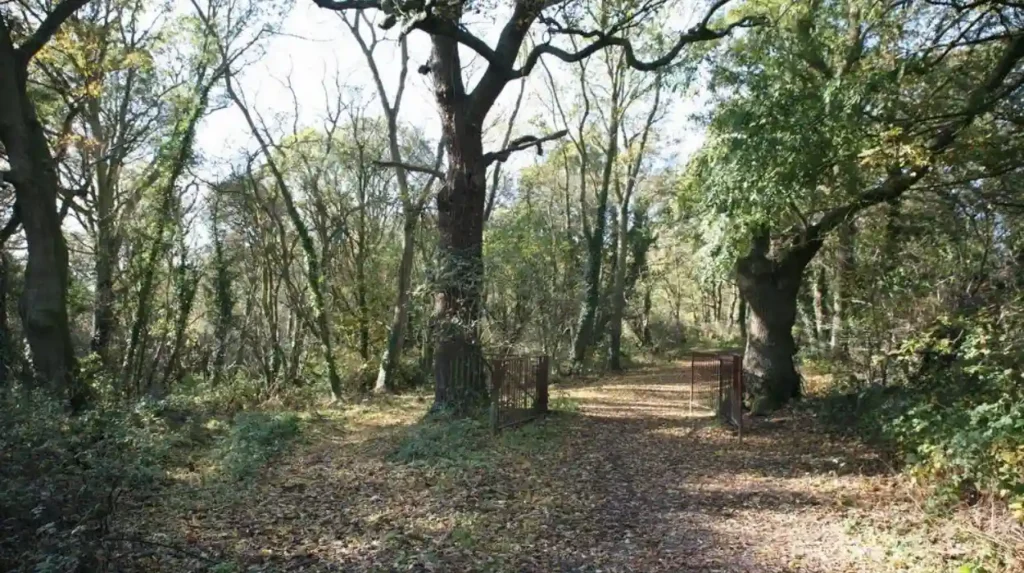
The borough’s woodland is not confined to one large forest. It includes different woodland landscapes distributed across the borough. Important examples include Scratchwood, Barnet Gate Wood, Big Wood, Little Wood and Monken Hadley Common.
Barnet Council identifies Scratchwood, Barnet Gate Wood and Big Wood and Little Wood among its ancient woodlands. It also identifies Scratchwood and Moat Mount, together with Monken Hadley Common, among the borough’s largest woodland areas.
Scratchwood is particularly important. The council describes it as part of the largest woodland area in Barnet when combined with Moat Mount. The woodland contains ancient woodland dominated by oak and hornbeam, alongside spring woodland flowers and habitats supporting wildlife.
This woodland network gives Barnet a different green character from boroughs where green space is dominated by large formal parks or sports grounds.
How much public open space does Barnet have?
Barnet has a substantial public open-space network containing parks, recreation grounds, natural areas, sports sites, green chains and other spaces. Council evidence records more than 200 open spaces, while later planning documents identify about 1,192 hectares of public open space.
Public open space is important because green land is not automatically accessible to visitors. Private gardens, agricultural land and restricted ecological sites contribute to green-cover statistics without providing the same recreational opportunities.
Barnet’s historic open-space assessment identified 208 open spaces covering approximately 888.7 hectares. This included public parks, playgrounds, sports sites, natural and semi-natural greenspace, combination sites and other greenspaces.
Barnet’s Local Plan recreation evidence gives a broader figure of approximately 1,192 hectares of public open space and records 10 district parks and 77 local parks.
These figures come from different documents and methodologies, so they should not be treated as directly interchangeable. They demonstrate the scale of Barnet’s open-space network rather than establish one definitive current total.
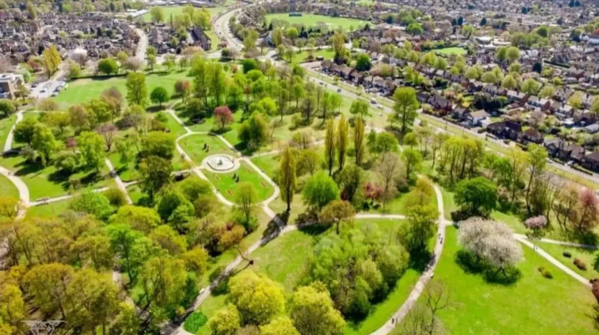
The council’s current parks directory lists a large network of parks and open spaces across locations including Mill Hill, High Barnet, Finchley, Whetstone, Edgware, East Barnet, Arkley and Hendon.
For visitors, this distribution is significant. Green space is not concentrated in one destination. Travellers can access different landscapes depending on where they are staying or travelling through the borough.
Formal parks provide lawns, paths, playgrounds and sports facilities. Natural areas provide woodland, scrub, meadow and wetland habitats. Green corridors connect different environments and support walking and cycling.
Which woodlands make Barnet particularly green?
Barnet’s strongest woodland assets include Scratchwood, Moat Mount, Barnet Gate Wood, Big Wood, Little Wood and Monken Hadley Common. These areas combine ancient woodland, mature trees, grassland, wildlife habitats and walking opportunities across northern London.
Scratchwood and Moat Mount form one of Barnet’s most important woodland landscapes. Scratchwood contains ancient woodland with oak and hornbeam. Moat Mount contains extensive woodland and former ornamental-garden landscapes.
Barnet Gate Wood is another ancient woodland area. It forms part of the borough’s northern landscape around Arkley and contributes to the wider ecological network.
Big Wood and Little Wood sit within Hampstead Garden Suburb. Their woodland character provides a natural contrast with surrounding residential development.
Monken Hadley Common is another major open landscape. It combines woodland and common land and forms part of the historic northern Barnet landscape.
These woodlands also demonstrate how Barnet’s green infrastructure operates at different scales. A large woodland provides habitat and canopy. Smaller woodland fragments provide local access to nature. Connecting habitats create ecological corridors.
The borough’s 2026–2036 Parks and Open Spaces Strategy records 71.5 hectares of ancient woodland, equivalent to approximately 0.8% of the borough, alongside 611.8 hectares of deciduous woodland, equivalent to approximately 7.1%.
Ancient woodland has particular ecological significance because it has developed over long periods and supports distinctive soils, fungi, plants, invertebrates and wildlife communities.
The presence of ancient woodland also gives Barnet an important conservation responsibility. Protecting individual woodland sites is not sufficient if surrounding habitats become isolated. Connectivity between green spaces remains an important planning consideration.
How important are Barnet’s nature reserves and conservation sites?
Barnet contains one Site of Special Scientific Interest, seven Local Nature Reserves and 66 Sites of Importance for Nature Conservation. These designations protect habitats ranging from woodland and grassland to wetlands, riverside environments and reservoirs.
Nature conservation designations provide a stronger ecological measure than green-cover percentages alone.
Barnet’s current Parks and Open Spaces Strategy records one Site of Special Scientific Interest, seven Local Nature Reserves and 66 Sites of Importance for Nature Conservation. The SSSI covers 0.38% of the borough, Local Nature Reserves cover 1.76%, and SINCs cover 13.41%.
A Site of Special Scientific Interest, or SSSI, is a nationally important site designated because of its wildlife, geology or physiographical features. Barnet contains the Welsh Harp, also known as Brent Reservoir, as its principal SSSI.
A Local Nature Reserve, or LNR, is a site designated for local nature conservation and public enjoyment. Barnet’s LNR network includes Rowley Green Common, Oak Hill Woods, Scratchwood and Moat Mount, Coppetts Wood and Glebelands, Totteridge Fields, and Big Wood and Little Wood.
A Site of Importance for Nature Conservation, or SINC, is part of London’s ecological designation system. SINCs identify places that have wildlife value at metropolitan, borough or local level.
Barnet’s 66 SINCs include woodland, parks, grasslands, railway land, cemeteries, watercourses and other habitats. The current strategy states that these sites cover 13.4% of the borough.
This network makes Barnet more than a borough with large areas of grass and trees. It has a recognised ecological structure supported by formal conservation designations.
How does Barnet’s Green Belt compare with its parks?
Barnet’s Green Belt protects large areas from inappropriate development, while parks provide more direct recreational access. The borough has approximately 28% of its area designated as Green Belt, making countryside protection a major part of its green character.
Green Belt is a planning designation, not a synonym for public parkland. Its purpose is to control development and prevent urban sprawl, maintain openness and support other planning objectives.
Barnet’s planning evidence identifies approximately 28% of the borough as Green Belt.
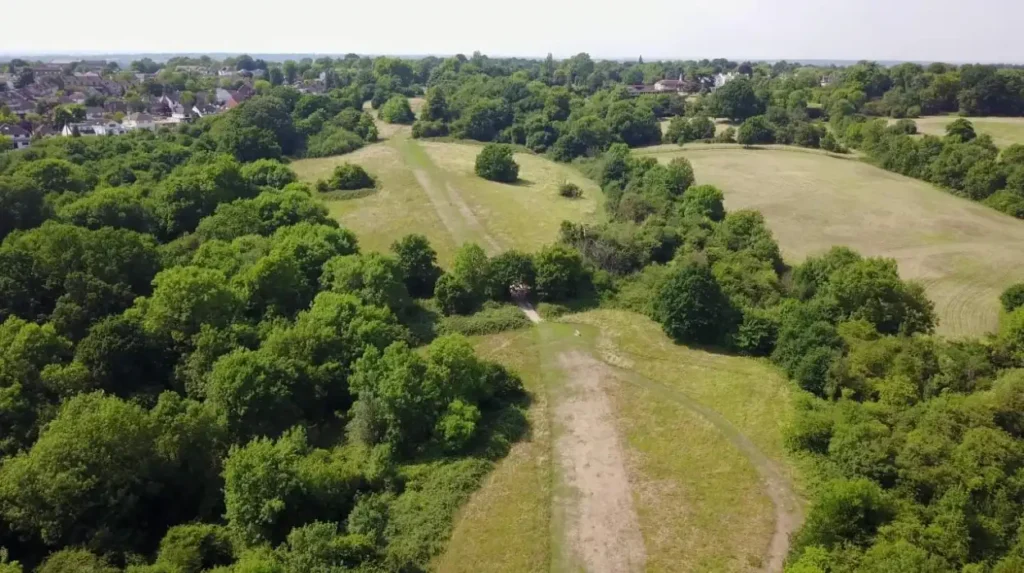
The Green Belt is especially important in northern Barnet, where fields, woodland, commons and agricultural landscapes create a transition between London’s built-up area and the wider countryside.
Some Green Belt land is publicly accessible. Other land remains privately owned or managed for agriculture and other uses.
This distinction matters when comparing Barnet with boroughs that have large public parks. A visitor should not assume that every green area visible on a map is accessible.
Barnet also contains Metropolitan Open Land, or MOL. MOL is another strategic planning designation used to protect important open land within London. The London Plan gives specific protection to Green Belt and Metropolitan Open Land through its green-infrastructure policies.
The relationship between Green Belt, MOL, parks, nature reserves and SINCs creates overlapping layers of protection and function.
As you explore the modern green landscape, you are crossing land shaped by centuries of development and conservation. Read about the full [Insert Anchor Text for History Article Here] to understand its origins.
Which conservation landscapes are most significant for visitors?
Visitors seeking Barnet’s strongest natural landscapes should focus on Scratchwood and Moat Mount, Totteridge Fields, Rowley Green, Oak Hill Woods, Big Wood and Little Wood, plus the Welsh Harp and its surrounding open spaces.
Barnet offers different types of green experience within a relatively compact London borough.
Scratchwood and Moat Mount are suitable for woodland-focused visits. Their mature trees, wildlife habitats and walking routes provide a natural environment distinct from formal urban parks.
Totteridge Fields provides open countryside and meadow character. The area forms part of Barnet’s northern ecological network.
Rowley Green Common provides another example of protected natural landscape. Its location near Arkley connects visitors with the more rural side of Barnet.
Glebelands demonstrates how nature reserves can exist close to dense urban development. The reserve contains woodland, scrub, grassland and ponds and includes a nature trail.
The Welsh Harp is particularly important because it combines water, wetland, open space and wildlife habitat. The reservoir is also designated as an SSSI and forms part of the wider ecological network associated with the River Brent.
These locations provide different forms of recreation. Walking, wildlife observation, informal exercise, photography and quiet outdoor activities are all supported by Barnet’s green network.
Is Barnet greener than Enfield, Brent and Camden?
Barnet has higher green cover than Enfield, Brent and Camden under the GLA’s 2024 assessment. Barnet records 56.4%, compared with 54.5% in Enfield, 36.9% in Brent and 40.7% in Camden.
Enfield is Barnet’s closest comparison by green-cover percentage. Its 54.5% green cover remains substantial, but Barnet records 56.4%.
The comparison with Brent is more pronounced. Brent records 36.9% green cover, while Barnet records 56.4%.
Camden records 40.7% green cover. Although Camden contains major green destinations, including Hampstead Heath, its overall borough geography is more urbanised than Barnet’s.
Barnet also has higher tree canopy than both Enfield and Brent. Barnet’s canopy is 24.12%, compared with 17.11% in Enfield and 15.28% in Brent. Camden, however, records 28.36% tree canopy, showing that high tree coverage does not always correspond directly with a higher overall green-cover percentage.
This demonstrates why a single ranking can misrepresent London’s green geography.
Is Barnet greener than Bromley and Croydon?
Barnet has less green cover than Bromley but more than Croydon under the GLA’s 2024 mapping. Bromley records 73.6%, Barnet 56.4%, and Croydon 51.1%, placing Barnet between these two boroughs.
Bromley is the clearest benchmark for a greener London borough by overall green-cover percentage. Its 73.6% green cover is dramatically higher than Barnet’s 56.4%.
Bromley also records 27.14% tree canopy, compared with Barnet’s 24.12%.
Croydon records 51.1% green cover and 20.76% tree canopy. Barnet therefore exceeds Croydon on both measures.
The comparison places Barnet firmly within London’s greener outer-borough group.
Bromley, Barnet and Croydon also demonstrate the importance of borough size and land-use history. Large outer boroughs retain more space for woodland, agriculture, parks, reservoirs, playing fields and undeveloped land.
Barnet’s distinctive strength is the combination of these landscapes with a substantial urban population and extensive transport connections.
Why does Barnet’s green space matter for climate and biodiversity?
Barnet’s green infrastructure supports cooling, flood management, biodiversity, recreation and ecological connectivity. Parks, woodland, grassland and watercourses perform environmental functions that extend beyond leisure and contribute to London’s wider climate resilience.
Green infrastructure means the connected network of green and blue assets that provides environmental, social and economic benefits.
The London Plan identifies green infrastructure as a strategic part of London’s planning system. It states that green and open spaces provide social, health and environmental benefits and that connectivity between open spaces supports walking, cycling and wildlife corridors.
Barnet Council similarly identifies parks, woodlands and open spaces as important for cooling streets, reducing flood impacts and providing wildlife habitat.
Trees provide shade and contribute to urban cooling. Vegetated soils absorb rainfall and reduce surface-water pressure. Wetlands and watercourses provide habitat and contribute to ecological networks.
Barnet’s river systems are also important. The borough lies within the River Brent catchment, with the Dollis Brook and Silk Stream forming parts of the local water network. These watercourses connect green spaces and support wildlife habitats.
The Welsh Harp provides an especially important blue-green landscape. Its reservoir, marginal habitats and surrounding open spaces combine water management, biodiversity and recreation.
The environmental value of Barnet’s green spaces therefore depends on quality and connectivity as well as total area.
Explore More Area Guide
What Wildlife Can You See in Barnet North London 2026
Where to Experience Barnet Arts and Creative Scene North London 2026
How is London measuring green infrastructure in 2026?
London now uses the Green Infrastructure Framework and Local Nature Recovery Strategy to assess green infrastructure needs, nature recovery opportunities and investment priorities. These tools provide a more detailed basis for comparing boroughs than simple green-space percentages.
The London Green Infrastructure Framework, or LGIF, was published in 2026 as a strategic evidence tool for planning and prioritising green infrastructure across London. It brings together London-wide spatial data and supports borough-level analysis.
The LGIF covers ten green-infrastructure objectives. These include areas such as access to green space, urban cooling and other benefits provided by green infrastructure.
The London Local Nature Recovery Strategy, or LNRS, has a more specific biodiversity focus. It identifies existing designated wildlife areas, opportunities for nature recovery and strategic priorities for improving nature across London.
The distinction is important.
Green-cover data answers a question about the physical amount of vegetation. The LGIF examines the wider functions of green infrastructure. The LNRS focuses specifically on nature recovery.
Together, these approaches provide a more sophisticated framework for understanding Barnet’s environmental position.
The GLA’s updated green-cover map estimates London-wide green cover at 51.68%, while Barnet records 56.4%. This establishes Barnet as greener than the London average by this specific metric.
Future comparisons should therefore consider green cover, tree canopy, accessibility, biodiversity, ecological connectivity and climate benefits rather than relying on one percentage.
What is the overall verdict on Barnet’s green credentials?
Barnet is one of London’s greener boroughs, but it is not the greenest by every measure. Its 56.4% green cover, 24.12% tree canopy, extensive open space, woodland, Green Belt and conservation network place it well above many London boroughs.
The evidence gives Barnet a strong position in London’s green-space landscape.
Its 56.4% green cover exceeds the London average of 51.68%. Its 24.12% tree canopy exceeds the London average of 19.56%.
Its environmental network also contains 71.5 hectares of ancient woodland, 611.8 hectares of deciduous woodland, seven Local Nature Reserves, 66 Sites of Importance for Nature Conservation and one principal SSSI.
Approximately 28% of the borough is Green Belt, reinforcing the importance of protected open landscapes in northern Barnet.
Bromley is greener by overall green-cover percentage, at 73.6%. Enfield follows closely behind Barnet at 54.5%, while Croydon records 51.1%. Barnet therefore occupies a strong position among London’s greener boroughs without being the city-wide leader.
For tourists and leisure travellers, Barnet’s advantage is the variety of green environments. Visitors can move between formal parks, ancient woodland, open countryside, nature reserves, riverside landscapes and the Welsh Harp.
For residents and workers, the same network provides access to nature, walking routes, recreation and environmental benefits.
For future planning, Barnet’s challenge is maintaining the quality and connectivity of these spaces while accommodating development and responding to climate pressures.
The most accurate conclusion is therefore clear: Barnet is significantly greener than the London average and ranks among London’s greener boroughs, with a particularly strong combination of tree canopy, woodland, open space, Green Belt and designated nature sites.
Is Barnet one of the greenest boroughs in London?
Yes, Barnet is one of London’s greener boroughs, with 56.4% green cover and 24.12% tree canopy cover. It ranks above the London average for vegetation and woodland coverage, although Bromley has a higher overall green-cover percentage.