Victorian Barnet was a changing collection of villages, market settlements, farmland and emerging suburbs on the northern edge of London. Between 1837 and 1901, railways, new roads, churches, schools, utilities, shops and housing transformed the area. The modern London Borough of Barnet did not yet exist, so Victorian Barnet consisted of several separate civil parishes and developing communities.
- How did Barnet change during the Victorian era?
- Was Barnet rural or urban in Victorian times?
- How did the railways transform Victorian Barnet?
- What was High Barnet like in the Victorian period?
- Which Victorian buildings can still be seen in Barnet?
- How did Victorian housing change Barnet?
- What was daily life like for people in Victorian Barnet?
- How did gas and water services affect Victorian Barnet?
- How did Victorian Barnet’s population grow?
- What role did churches and religion play in Victorian Barnet?
- How important were markets, shops and inns in Victorian Barnet?
- What can visitors see today from Victorian Barnet?
- Why does Victorian Barnet still matter today?
The period is important because it established much of the built character and transport pattern that visitors can still recognise today. High Barnet retained its historic market-town role, while New Barnet, Finchley, Hendon and surrounding settlements developed stronger connections with London.
Barnet Council describes the wider area as growing from about 6,400 people living in villages in the mid-19th century to a much larger suburban population later. The council also notes that boundaries changed frequently, making direct historical population comparisons difficult.
How did Barnet change during the Victorian era?
Victorian Barnet changed from a mainly rural and market-based district into a more connected collection of settlements shaped by railways, roads, housing, commerce, public services and expanding links with London between 1837 and 1901.
At the beginning of Queen Victoria’s reign in 1837, Barnet was not a single urban borough. Local administration was divided between places including Chipping Barnet, Hadley and South Mimms. East Barnet, Finchley, Hendon, Totteridge and other settlements also had their own identities and administrative arrangements.
High Barnet already had an established role as a market and coaching centre. Its position on the historic northern route from London gave it commercial importance. Barnet High Street had been the principal shopping area since at least the 18th century.
The Victorian period accelerated change rather than creating Barnet from scratch.
Road improvements had already altered movement through the town. Between 1818 and 1823, the Great North Road was improved through Barnet. The new alignment reduced the steepness of the route from Underhill. This improved the movement of people, goods and military traffic.
Railways then produced a more significant transformation.
Barnet Station opened in 1850. It later became known as New Barnet Station. A railway branch reached High Barnet in 1872, creating stronger links with London. Totteridge and Whetstone also received a railway station in 1872.
The result was a more complex landscape. Historic streets and market buildings remained alongside new roads, railway infrastructure, suburban houses, churches and public institutions.
Was Barnet rural or urban in Victorian times?
Victorian Barnet was neither completely rural nor fully urban. High Barnet functioned as a market town, while New Barnet and railway corridors gained suburban development, and areas such as Arkley, East Barnet and surrounding farmland retained substantial rural characteristics.
The distinction between town and countryside was especially important in the 19th century.
High Barnet had a dense historic core centred on the High Street, Wood Street and St John the Baptist Church. Shops, inns, workshops and houses occupied the main routes. The market provided an established commercial function.
Outside the centre, the landscape remained much less built up.
Barnet Council records that railway development encouraged suburban roads in New Barnet and Brunswick Park. However, railway fares were expensive, limiting the immediate spread of commuting. East Barnet, Arkley and Mays Lane retained rural characteristics during much of the Victorian period.
This created a mixed landscape.
A Victorian visitor travelling through the district encountered a market town, agricultural land, large houses, village settlements and new railway development within a relatively short distance.
The transformation was therefore gradual. Suburbanisation did not cover the entire area at once.
New Barnet provides a clear example. Before the railway arrived, there was no settlement known as New Barnet. The Great Northern Railway acquired land from farms and estates to construct its route. The British Land Company subsequently developed parts of the Lyonsdown estate for housing.
By the 1860s, roads such as Leicester Road, Lytton Road and Lyonsdown Road had been established. Yet development remained incomplete for decades.
How did the railways transform Victorian Barnet?
The railways connected Barnet more directly with London, encouraged new housing, created employment and established new settlement centres, while also changing the importance of older coaching routes and rural land around the stations.
Railway development was one of the defining forces of Victorian Barnet.
The first Barnet railway station opened in 1850. The station later became New Barnet. The Edgware, Highgate and London Railway opened its branch to High Barnet in 1872 after the Great Northern Railway had taken over the line.
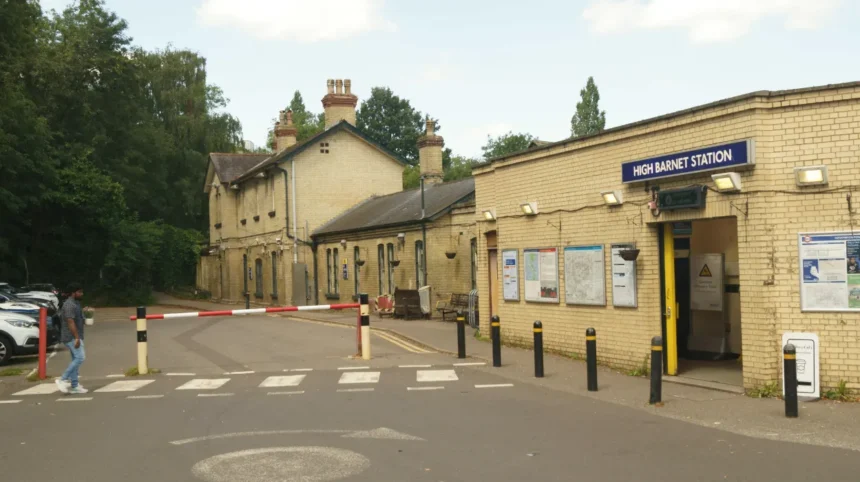
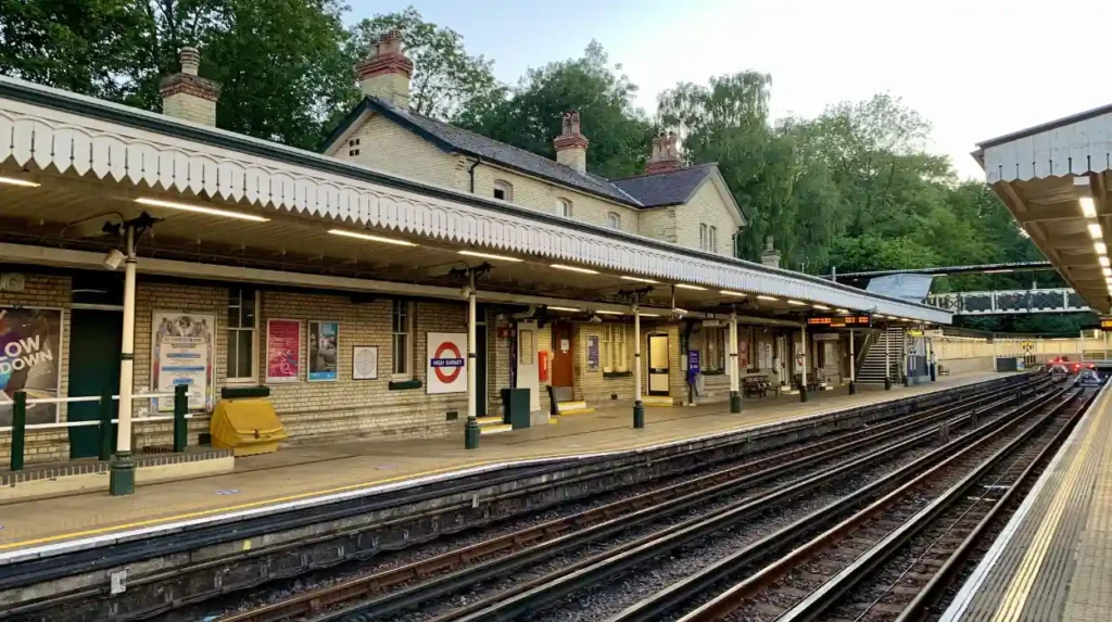
High Barnet railway station retains strong evidence of its Victorian origins. Barnet’s local heritage documentation identifies its yellow-brick station buildings, slate roofs, sash windows, chimney stacks, waiting rooms, footbridge and canopy supports as surviving elements of its original character.
Railways affected land values and settlement patterns.
New roads appeared near stations. Housing developers purchased land and laid out streets. Shops followed residential growth. Churches and schools were established to serve expanding communities.
New Barnet illustrates this process particularly clearly.
The British Land Company sold houses along New Barnet Road from 1857. Holy Trinity Church was established in 1864, while the parish of Lyonsdown was created in 1869. A school for 400 children opened in 1871. Gas and water infrastructure followed.
The railway therefore created more than a transport connection. It generated a development corridor.
What was High Barnet like in the Victorian period?
High Barnet remained the historic commercial centre, with a busy High Street, market traditions, coaching inns, churches, shops and public institutions, while late Victorian development added new streets and buildings around its established town core.
High Barnet had centuries of history before Queen Victoria came to the throne.
The settlement developed around the historic road north from London. Its market existed in various forms from at least the 12th century. The name Chipping Barnet reflects the historic market-town identity.
During the Victorian period, the High Street remained commercially important.
Its businesses served residents, travellers and surrounding rural communities. Inns continued to form part of the town’s commercial landscape. Printers, food retailers, tradespeople and other businesses operated along the main streets.
The arrival of the railway in 1872 strengthened the town’s connection with the capital.
The Victorian High Street also contained evidence of older building phases. The famous narrow section known as the “Squeeze” survived between the King’s Head and St John the Baptist Church. The area had previously contained Middle Row, where shops stood in the road and where the market was historically located.
A fire destroyed Middle Row in 1889.
That event illustrates the changing appearance of the town.
Older market structures were disappearing while new Victorian streets and buildings were being introduced.
Visitors exploring modern High Barnet can still trace these layers of development through the High Street, Wood Street, church precinct and surrounding historic streets.
Which Victorian buildings can still be seen in Barnet?
Victorian Barnet survives through railway buildings, churches, schools, houses, civic structures and commercial premises, with High Barnet Station and St John the Baptist Church providing two particularly important examples of the period’s architecture.
Architecture provides some of the clearest evidence of Victorian Barnet.
St John the Baptist Church is especially significant. The church occupies a site with much older religious history, but the Victorian building is largely the result of a major reconstruction.
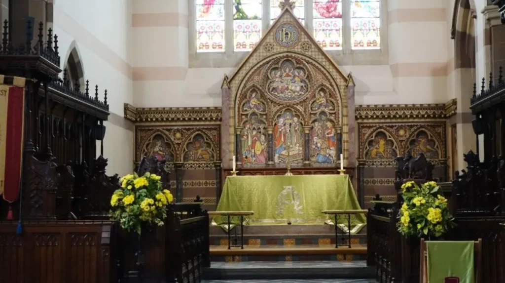
In 1875, the church was almost completely rebuilt at a cost of £16,000 to designs by William Butterfield, a major architect associated with Victorian Gothic architecture. The north aisle is the principal surviving part of the earlier 15th-century building.
The church demonstrates how Victorian communities invested in existing institutions rather than simply replacing them.
High Barnet Station provides another important architectural example. Its yellow brick, slate roofing, sash windows and railway structures represent the standard architectural language of Victorian railway development.
New Barnet contains further evidence.
Holy Trinity Church dates from 1864. The surrounding streets reflect the expansion of the railway settlement. New Barnet Town Hall was constructed in 1892 for the local board.
In North Finchley, Christ Church was built between 1867 and 1869 as a mission church serving railway workers involved in constructing the London, Highgate and Edgware Railway. Designed by John Norton in Gothic style, it was expanded in stages, including aisles in 1874 and a chancel, side chapel and vestry in 1891.
These buildings demonstrate the relationship between transport, population growth, religion and architecture.
As you explore the modern town centre, you are crossing land with a much deeper heritage. Read about the full to understand its origins.
How did Victorian housing change Barnet?
Victorian housing expanded most strongly around railway corridors and newly planned roads, producing terraces, villas and other suburban forms while older villages, farms and open land continued to survive beyond the developing settlement centres.
Housing was a visible measure of Barnet’s Victorian transformation.
Before the railways, settlement patterns were largely inherited from older villages, farms, estates and roads. Railway companies and land developers introduced a new logic based on access to stations.
New Barnet is the clearest example.
The railway company acquired land through the Lyonsdown estate. The British Land Company acquired and marketed parts of the remaining estate. Roads were laid out, followed by houses.
Development was not immediate.
By the 1890s, many roads existed but remained partly undeveloped. Barnet Council records that an Ordnance Survey map from the mid-1890s showed Victorian roads that were already decades old but still contained vacant plots. New Barnet was not fully built until the period around the First World War.
This is important when interpreting Victorian suburbanisation.
A street created in the Victorian period did not necessarily contain continuous rows of houses immediately. Development took place over several decades.
The resulting housing included terraces and villas associated with the expanding middle-class and working populations. Larger houses also appeared in some parts of Barnet and Hendon.
Brent Street in Hendon, for example, had several large Victorian mansions, including Tenby Mansion, dating from about 1845. Shops appeared in the area during the 1850s, while new streets were developed as the settlement expanded.
What was daily life like for people in Victorian Barnet?
Daily life combined traditional market-town activities with expanding Victorian services, including shops, churches, schools, policing, newspapers, gas lighting and improved water supplies, while occupation and living conditions varied sharply between social groups and locations.
Victorian Barnet was a working community.
The High Street supported retailers and tradespeople. Inns served travellers. Printers and newspaper publishers provided local information. Farmers and agricultural workers remained important outside the growing urban areas.
The Barnet Press began in 1859 after the sons of printer John James Cowing established a newspaper using the family printing business.
Education also expanded.
Queen Elizabeth’s Girls’ School opened in High Barnet in 1888. New Barnet had a school for 400 children by 1871. These institutions reflected the growing importance of organised education in Victorian communities.
Policing became more formal.
Barnet had been part of the Metropolitan Police district since 1840. High Barnet subsequently had several police stations, including buildings established during the 1860s.
New Barnet also developed its own police provision. A police station opened in 1884 with one inspector, three sergeants and 15 constables.
These institutions indicate how Victorian settlements developed increasingly organised public services.
How did gas and water services affect Victorian Barnet?
Gas and water infrastructure improved everyday urban services in Victorian Barnet by supporting street lighting, household supply and public development, with New Barnet establishing gas and water facilities as its population and institutions expanded.
Modern visitors often notice Victorian architecture but overlook the infrastructure beneath everyday life.
New Barnet provides strong evidence of this change.
The East Barnet Gas and Water Company established a gasworks in 1872. Gas supplied lamps that illuminated houses. The same company supplied drinking water from a 500-foot artesian well.
These services changed the practical experience of urban life.
Gas lighting extended useful activity after dark and improved illumination around streets and buildings. A reliable water supply supported homes, schools and other institutions.
Infrastructure also helped distinguish an emerging suburb from a rural settlement.
The creation of gasworks, waterworks, schools, churches and police facilities demonstrates that New Barnet was becoming an established community rather than simply a collection of houses beside a railway.
How did Victorian Barnet’s population grow?
Barnet’s population increased as railway development, housing construction and London connections encouraged settlement, although historical figures must be compared carefully because Victorian administrative boundaries differed from those used by modern Barnet.
Population growth was substantial but uneven.
Barnet Council states that the wider area grew from approximately 6,400 people living in villages in the mid-19th century to 345,800 residents by 2010. The figures describe a long-term transformation rather than a single Victorian population series.
New Barnet offers more precise Victorian evidence.
The new parish of Lyonsdown had 2,340 residents in 1871. By 1881, the population had increased to approximately 4,230.
Monken Hadley provides another long-term historical series. Its population was 1,003 in 1851, 978 in 1871, 1,160 in 1881 and 1,294 in 1891. It reached 1,389 by 1901.
These figures show that population growth did not occur uniformly.
Some railway settlements expanded rapidly. Other rural parishes changed more slowly.
Barnet Town recorded 8,367 residents in 1901, rising to 10,440 in 1911. These figures help demonstrate the continuing expansion after the Victorian period.
The key historical point is that “Barnet” did not have one consistent Victorian boundary. Modern borough statistics therefore cannot simply be applied to the 19th century.
What role did churches and religion play in Victorian Barnet?
Churches served expanding Victorian communities as places of worship, parish administration, education and social organisation, with new or rebuilt churches appearing alongside railway-led population growth in High Barnet, New Barnet and surrounding settlements.
Religion remained central to Victorian community life.
Population growth created demand for additional churches and parish structures.
In High Barnet, St John the Baptist Church was substantially rebuilt in 1875. The project produced one of the area’s most important examples of Victorian Gothic architecture.
In New Barnet, Holy Trinity Church opened in 1864 and gained its own parish at Lyonsdown in 1869.
Churches were also closely connected with education and social organisation.
The architectural style reflected wider Victorian preferences. Gothic Revival architecture became especially influential in ecclesiastical buildings. St John the Baptist Church demonstrates this through William Butterfield’s design.
Christ Church in North Finchley provides another example. John Norton’s Gothic building was established partly in response to railway construction and the growing population associated with it.
The pattern is clear: transport growth created communities, while churches helped structure those communities.
How important were markets, shops and inns in Victorian Barnet?
Markets, shops and inns remained essential to Barnet’s Victorian economy because High Barnet served local residents, surrounding rural communities and travellers using the northern road, while new suburbs gradually developed their own commercial centres.
High Barnet’s commercial identity was older than the Victorian era.
The market had existed in different forms since at least the 12th century. By the 18th century, the High Street had become the main shopping area.
Victorian businesses continued this tradition.
The High Street contained retailers and tradespeople serving everyday needs. Barnet’s historic position on a major route also sustained inns and traveller-related businesses.
The arrival of railways changed the pattern without eliminating the older commercial role.
New Barnet developed shops during the 1880s. Its commercial growth followed residential expansion and the establishment of public institutions.
This created two overlapping economic models.
High Barnet retained the established market-town economy. New Barnet developed a railway-suburban economy.
The two environments were connected but distinct.
Explore More Area Guide
How Barnet’s Population Grew Over Time: History and Census Data
Medieval Features in Barnet | Historic Sites & Heritage
What can visitors see today from Victorian Barnet?
Modern visitors can still identify Victorian Barnet through High Barnet Station, St John the Baptist Church, New Barnet’s historic streets, Victorian churches, surviving commercial buildings and the road patterns created during the 19th-century expansion.
The Victorian landscape survives in fragments rather than as a complete preserved town.
High Barnet is the strongest starting point.
Visitors can examine the High Street, the historic “Squeeze”, St John the Baptist Church and surrounding streets. The church and railway station provide particularly clear architectural evidence.
High Barnet Station is valuable because many original Victorian features remain. Its station buildings preserve the architectural character associated with 1872 railway construction.
New Barnet provides a different experience.
Its Victorian identity is visible in the layout of roads, railway infrastructure, Holy Trinity Church and former civic development. The streets demonstrate how land once occupied by farms and estates was gradually converted into suburban housing.
Barnet Council maintains extensive historical resources, including maps, photographs, newspapers, directories and archival records. Its local studies collection contains documents dating from 1600 onwards.
The council also identifies 19th-century Ordnance Survey maps from approximately 1864 and 1896 as useful resources for studying the physical development of the area.
For visitors interested in historical geography, comparing these maps with modern streets provides a practical way to understand Victorian change.
Why does Victorian Barnet still matter today?
Victorian Barnet still matters because the period established transport routes, streets, buildings, institutions and settlement patterns that continue to influence the area’s identity, heritage landscape and relationship with London more than a century after Queen Victoria’s reign.
The Victorian period explains much of Barnet’s transition into a northern London suburb.
Railways connected settlements more closely with London. New roads created housing opportunities. Churches and schools followed population growth. Gas, water and policing created more structured urban services. Shops and businesses expanded around new communities.
The transformation was incomplete by 1901.
Some areas remained rural. New Barnet was still developing. Later tramways, underground railways and 20th-century housing produced much larger suburban expansion. Barnet Council records that extensive suburban development did not accelerate across many areas until after the arrival of tram services in 1907 and later changes to the railway network.
This makes the Victorian era an important middle stage rather than the final point in Barnet’s development.
Today’s Barnet contains multiple historical layers. Medieval churches, 18th-century buildings, Victorian railway infrastructure, Edwardian streets and later suburban developments occupy the same broad landscape.
For tourists, this history provides a way to understand the area beyond its modern identity. For residents, it explains why different parts of Barnet have distinct architectural and spatial characters. For visitors with limited time, the historic High Street, St John the Baptist Church and High Barnet Station provide a concentrated introduction to the area’s Victorian transformation.
The most important legacy of Victorian Barnet is therefore its transition from a collection of established rural and market communities into a connected suburban landscape. The railway, road, housing and civic improvements of the 19th century created the foundations for the much larger Barnet that developed during the 20th century.
What was Barnet like during the Victorian era?
Victorian Barnet was a mixture of market-town streets, villages, farmland and emerging suburbs. Railways, new housing, churches, schools, shops, gas lighting and improved water supplies gradually transformed the area between 1837 and 1901.