Barnet is one of London’s largest outer boroughs and an important location for residential development, commercial investment and urban regeneration. Situated in North London, the London Borough of Barnet is undergoing significant changes through new housing schemes, transport improvements, employment developments and the renewal of existing neighbourhoods.
- What Are Barnet’s Main Development and Regeneration Areas?
- Why Is Brent Cross and Cricklewood Barnet’s Largest Development Area?
- What Is Brent Cross Town?
- How Has Brent Cross West Improved Connectivity?
- What Does Brent Cross Mean for Visitors?
- Why Is Colindale a Major Residential Development Area in Barnet?
- What Is Driving Colindale’s Growth?
- What Facilities Are Being Developed in Colindale?
- Why Is Colindale Relevant to North London Visitors?
- What Is Happening in Mill Hill East?
- How Is Grahame Park Being Regenerated?
- How Many Homes Are Planned for Grahame Park?
- What Role Does Education Play in Grahame Park?
- How Does Regeneration Affect Existing Residents?
- Why Is Dollis Valley an Important Development Location?
- What Is the West Hendon Regeneration Project?
- Which Other Residential Estates Are Undergoing Development in Barnet?
- What Is Happening at Granville Road?
- What Was Delivered at Stonegrove and Spur Road?
- What Is the Approach to Upper and Lower Fosters?
- Which Barnet Town Centres Are Important for Future Development?
- Why Is Edgware an Important Growth Location?
- What Is the Development Potential of North Finchley?
- How Are Other Town Centres Contributing to Barnet’s Growth?
- How Is Barnet Planning Its Future Housing and Commercial Development?
- What Are Barnet’s Housing Targets?
- How Much Commercial Development Is Planned?
- Why Is Green Infrastructure Included in Development Planning?
- How Does Transport Infrastructure Influence Barnet’s Development Areas?
- What Role Does Brent Cross West Station Play?
- How Do Underground Stations Support Residential Growth?
- Why Are Walking and Cycling Routes Important?
- How Can Visitors Explore Barnet’s Development Areas?
- Where Can Visitors See Modern Urban Development?
- Which Areas Offer Access to Outdoor Recreation?
- Where Can Business Travellers Spend Their Downtime?
- How Has Barnet’s Development Changed Its Historical Landscape?
- What Are the Long-Term Implications of Barnet’s Development Programme?
- How Will Development Affect Local Employment?
- How Will Housing Growth Affect Local Communities?
- What Environmental Challenges Must Barnet Address?
- What Is the Future of Regeneration in Barnet?
- Where Is Barnet Experiencing the Most Significant Development?
The borough’s major development areas include Brent Cross and Cricklewood, Colindale, Mill Hill East, Grahame Park, Dollis Valley, West Hendon and several established town centres. These locations form part of Barnet Council’s wider strategy to accommodate population growth, improve local infrastructure and create sustainable communities.
Barnet’s development programme is not limited to constructing residential buildings. It also involves improving public spaces, creating employment opportunities, expanding community facilities and strengthening connections between neighbourhoods. These changes influence how residents, visitors, commuters and businesses experience North London.
Barnet Council adopted its Local Plan in March 2025, establishing a development strategy covering 2021–2036. The plan aims to support nearly 44,000 new homes, provide up to 67,000 square metres of additional office space and support approximately 27,000 jobs across the borough.
Understanding Barnet’s major development areas helps visitors identify changing neighbourhoods, residents understand local investment and business travellers recognise the borough’s emerging commercial centres.
What Are Barnet’s Main Development and Regeneration Areas?
Barnet’s main development areas include Brent Cross and Cricklewood, Colindale, Mill Hill East, Grahame Park, Dollis Valley, West Hendon and several residential regeneration estates. These locations combine new housing, commercial investment, transport improvements and community infrastructure.
Barnet Council organises regeneration around designated growth areas, priority regeneration estates and smaller development sites. Each category addresses different planning requirements. Growth areas accommodate larger-scale residential and commercial expansion, while estate regeneration programmes improve existing neighbourhoods.
The council’s regeneration programme identifies several important locations across the borough. These include:
- Brent Cross and Cricklewood: A major mixed-use development involving housing, offices, shopping, transport and public spaces.
- Colindale: A major residential growth location with new neighbourhood facilities and improved public infrastructure.
- Mill Hill East: A brownfield regeneration area transforming former institutional and industrial land into a residential neighbourhood.
- Grahame Park: A large estate regeneration project involving housing, education, health and community facilities.
- Dollis Valley: A residential redevelopment programme creating a mixed-tenure community.
- West Hendon: A neighbourhood regeneration project involving new homes, public spaces and community facilities.
- Granville Road: An estate improvement scheme providing additional housing and better public spaces.
- Stonegrove and Spur Road: A completed regeneration project delivering new housing, educational facilities and community amenities.
These locations demonstrate the different ways Barnet manages urban growth. Some developments introduce entirely new neighbourhoods, while others improve existing residential areas. Barnet Council+1
The distinction is important because regeneration involves more than increasing the number of properties. Successful development also requires transport capacity, accessible services, green infrastructure and facilities that support existing communities.
Why Is Brent Cross and Cricklewood Barnet’s Largest Development Area?
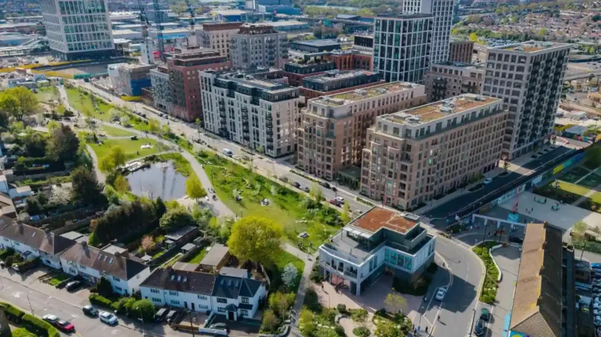
Brent Cross and Cricklewood is Barnet’s largest regeneration programme, combining a new residential neighbourhood, expanded retail facilities, office developments, public parks and transport improvements. Its central component, Brent Cross Town, covers approximately 180 acres.
Brent Cross and Cricklewood occupies a strategically important position in southern Barnet, close to the North Circular Road, the M1 motorway and major railway connections. Its location makes it suitable for residential development, retail investment and commercial activity.
The regeneration programme aims to transform the wider area into a mixed-use urban centre. It includes Brent Cross Town, improvements to Brent Cross Shopping Centre and supporting infrastructure across the surrounding development zone.
What Is Brent Cross Town?
Brent Cross Town is a new neighbourhood being delivered through a partnership between Barnet Council and Related Argent. The development covers approximately 180 acres and follows a net-zero development approach.
The planned neighbourhood includes:
- Up to 6,700 new homes.
- Approximately 3 million square feet of office space.
- Employment space supporting up to 25,000 jobs.
- Approximately 50 acres of parks and playing fields.
- New shops, restaurants, cafés and leisure facilities.
- Public squares, walking routes and cycling connections.
The project also includes new educational and community facilities. Its neighbourhood design follows a 15-minute town concept, which aims to place everyday services, workplaces and recreational facilities within convenient walking or cycling distances.
How Has Brent Cross West Improved Connectivity?
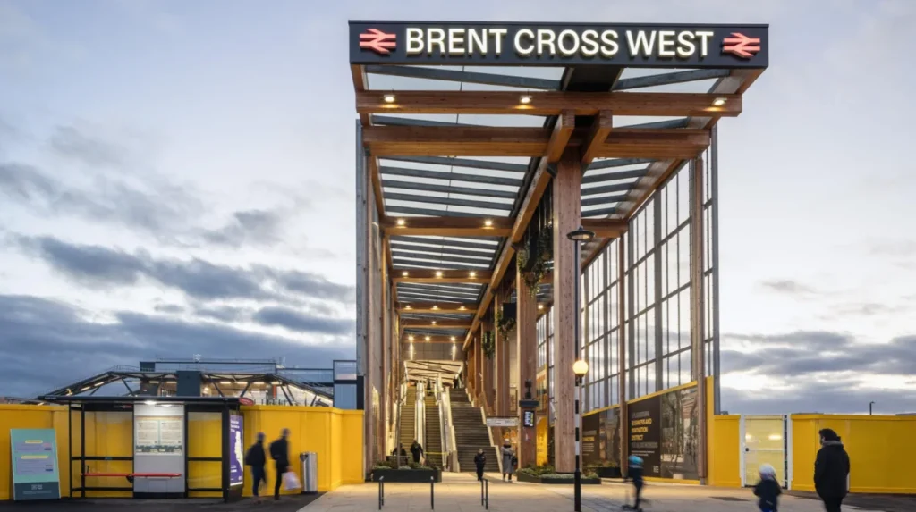
Brent Cross West railway station opened on 10 December 2023. It provides Thameslink services and creates a new connection between the regeneration area and central London.
The station supports access to the developing neighbourhood and improves connections across the railway corridor. A public pedestrian bridge also reconnects communities previously separated by the railway infrastructure.
For business travellers, the station provides an additional transport option when travelling between North London and central London. Visitors also benefit from improved access to the wider Brent Cross area.
What Does Brent Cross Mean for Visitors?
Brent Cross combines an established shopping destination with an emerging residential and commercial district. Visitors can explore Brent Cross Shopping Centre while observing the wider transformation taking place around the new town.
The area’s developing parks, public spaces, restaurants and commercial facilities will also contribute to its leisure and visitor offer.
Cricklewood is an important part of the wider regeneration geography. Its established high street, railway connections and residential neighbourhoods provide a different urban character from the newly planned Brent Cross Town.
Why Is Colindale a Major Residential Development Area in Barnet?
Colindale is one of Barnet’s largest residential growth areas, with new housing, improved transport infrastructure, educational facilities and community services. Its regeneration programme aims to create a connected neighbourhood with accessible public spaces and everyday amenities.
Colindale is situated in north-west Barnet, close to Edgware, Hendon and the borough boundary with Brent. The Northern line provides an important public transport connection through Colindale Underground station.
The area has experienced substantial residential development because of its available brownfield land and strategic location. Brownfield land refers to previously developed land that is suitable for potential redevelopment.
What Is Driving Colindale’s Growth?
Colindale’s transformation involves converting former employment, institutional and underused sites into residential neighbourhoods. New developments include apartment buildings, public spaces and supporting commercial facilities.
The Colindale Area Action Plan provides a planning framework for managing this growth. It addresses housing provision, transport, environmental improvements and the creation of a more cohesive neighbourhood.
The wider Colindale growth area also connects with development activity around Burnt Oak and The Hyde. This creates a larger regeneration corridor extending towards the western side of North London.
What Facilities Are Being Developed in Colindale?
Colindale’s regeneration includes several important public facilities:
- New residential accommodation, including affordable homes.
- Improved pedestrian and cycling routes.
- Educational facilities, including Barnet and Southgate College’s Colindale campus.
- Community facilities and public open spaces.
- Retail and neighbourhood services.
- Improvements to local transport infrastructure.
The relocation of Colindale Library and the development of educational facilities demonstrate the importance of public services within the regeneration programme. These facilities support residents beyond the immediate housing developments.
Why Is Colindale Relevant to North London Visitors?
Colindale offers an example of how a suburban area develops into a more densely populated urban neighbourhood. Visitors interested in architecture, residential planning and modern urban development can observe the changing streetscape.
The area also provides access to attractions such as the Royal Air Force Museum, which is located in Colindale and documents the history of aviation and the Royal Air Force.
For digital nomads and business travellers, Colindale’s transport connections, local cafés, shops and residential services provide useful facilities within North London.
What Is Happening in Mill Hill East?
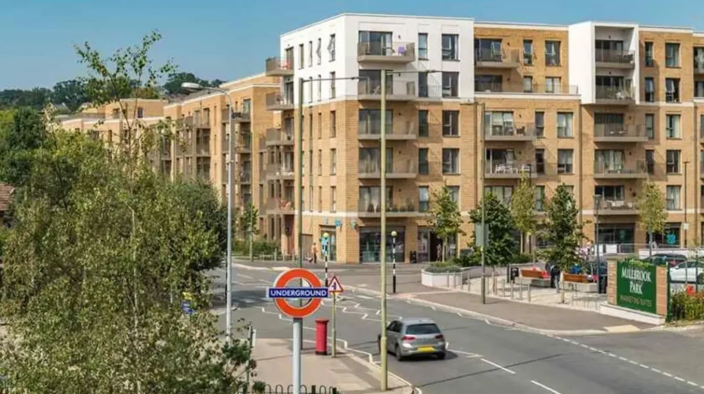
Mill Hill East is a major brownfield regeneration location in Barnet, where more than 40 hectares of previously developed land are being transformed into a residential neighbourhood. The Millbrook Park development includes new homes, transport improvements and supporting infrastructure.
Mill Hill East is situated in the eastern part of the borough, near Finchley and the wider Mill Hill neighbourhood. Its development is particularly significant because it involves the reuse of land previously occupied by Inglis Barracks and a council waste depot.
The regeneration programme demonstrates how former institutional and operational sites can accommodate residential growth without relying entirely on undeveloped land.
What Is the Millbrook Park Development?
Millbrook Park is the principal residential development associated with Mill Hill East regeneration. The project involves the redevelopment of more than 40 hectares of brownfield land.
Barnet Council identifies approximately 2,240 new homes as part of the programme. The development also includes improvements to Mill Hill East Underground station and enhanced bus services.
The regeneration process involves preparing the land, providing essential infrastructure and dividing the site into development parcels. Individual purchasers and developers then undertake detailed planning and construction work.
How Does Mill Hill East Support Sustainable Growth?
The area’s development uses previously developed land to accommodate additional housing. This approach supports urban regeneration while reducing pressure to develop entirely new sites.
Transport improvements are another important component. Access to the Northern line connects Mill Hill East with other parts of London, while improved bus services support local journeys.
For visitors, Mill Hill East offers access to established residential streets, local shops and nearby green spaces. Its development also provides an example of how infrastructure and housing investment reshape an established suburban location.
How Is Grahame Park Being Regenerated?
Grahame Park is a major residential regeneration area in Colindale, north-west Barnet. Its redevelopment involves approximately 4,000 new homes, improved transport connections, educational facilities, healthcare services, community spaces and changes to the existing estate layout.
Grahame Park is an established residential estate in the north-western part of Barnet. Its regeneration aims to replace outdated housing arrangements with a better-connected, mixed-tenure neighbourhood.
Mixed-tenure housing means a development includes different forms of housing ownership and occupation. These typically include social rented homes, affordable housing and private sale properties.
The programme addresses housing quality and the need for improved local services.
How Many Homes Are Planned for Grahame Park?
Barnet Council identifies approximately 4,000 new homes within the Grahame Park regeneration programme.
The development includes improvements to the residential environment and infrastructure. It also involves reorganising the estate to provide better connections between homes, streets and community facilities.
The council’s proposals include:
- Approximately 4,000 new homes.
- A replacement library.
- A community centre and children’s activity centre.
- Improved road, pedestrian and cycling networks.
- Better local bus services.
- Healthcare and community facilities.
- Improved public spaces.
These facilities are designed to support the growing population and improve access to essential services.
What Role Does Education Play in Grahame Park?
Education is an important part of the regeneration programme. Barnet and Southgate College relocated to a newly built campus in Colindale, providing further education facilities within the wider growth area.
The presence of educational institutions supports local skills development and employment opportunities. It also strengthens connections between residential development and the borough’s economic infrastructure.
How Does Regeneration Affect Existing Residents?
Estate regeneration involves significant changes to established residential environments. Housing replacement, construction activity and changes to local roads affect how residents experience their neighbourhood.
Grahame Park’s mixed-tenure approach aims to provide a wider range of housing options. Community facilities and public spaces also form part of the plan to maintain neighbourhood services during long-term growth.
The regeneration programme is therefore important for both existing households and people moving into newly developed homes.
Why Is Dollis Valley an Important Development Location?
Dollis Valley is a residential regeneration area in Barnet focused on replacing an existing system-built housing estate with modern mixed-tenure homes. The programme also provides improved community facilities, public spaces and infrastructure for a more integrated neighbourhood.
Dollis Valley forms part of Barnet Council’s priority regeneration programme. Its redevelopment addresses the condition and layout of the existing housing estate while providing additional residential accommodation.
System-built housing refers to properties constructed using standardised building systems or prefabricated components. The existing Dollis Valley estate required a wider redevelopment approach to improve housing quality and the surrounding environment.
What Facilities Are Included in Dollis Valley?
The regeneration programme combines residential development with community infrastructure. Its purpose is to create an integrated neighbourhood rather than simply replace existing buildings.
The development has delivered new mixed-tenure homes and community facilities. Hope Corner, a multipurpose community space, is one example of the facilities established through the wider regeneration programme.
The project also includes the re-provision of community and children’s day-care facilities. These services support families and provide spaces for neighbourhood activities.
Why Does Dollis Valley Matter for Barnet’s Future?
Dollis Valley demonstrates how estate renewal contributes to the borough’s wider housing strategy. It addresses existing housing conditions while improving the facilities available to residents.
For visitors exploring Barnet’s residential landscape, the area provides an example of neighbourhood-led physical change. Its development also demonstrates the importance of community infrastructure in large housing projects.
What Is the West Hendon Regeneration Project?
West Hendon is a major estate regeneration location in Barnet, involving new mixed-tenure housing, improved public spaces, better transport connections and additional community facilities. Its development aims to establish a more connected neighbourhood with improved residential amenities.
West Hendon is located in southern Barnet, near Hendon and the Welsh Harp reservoir. The area has an established residential character and access to major transport routes.
Its regeneration programme focuses on improving the existing estate and introducing new facilities. The wider development includes residential construction, public realm improvements and better connections with surrounding neighbourhoods.
What Is Included in West Hendon’s Development?
The regeneration programme includes several major components:
- New mixed-tenure residential properties.
- A new town square.
- Improved public spaces and streets.
- Better transport connections.
- A Community Hub.
- A new health centre.
The town square and public realm improvements are particularly important because they create shared spaces for residents and visitors.
Public realm refers to publicly accessible parts of the built environment, including streets, pavements, squares, parks and pedestrian routes.
West Hendon’s development therefore involves both private residential investment and improvements to shared neighbourhood infrastructure. Barnet Council+1
How Does West Hendon Connect with the Wider Borough?
West Hendon forms part of Barnet’s wider regeneration geography, which includes Brent Cross and Cricklewood.
Its location provides connections to the wider North London transport network. The area’s proximity to the Welsh Harp reservoir also creates an important relationship between residential development and outdoor recreation.
Visitors exploring West Hendon can combine an understanding of the regeneration programme with nearby walking routes and waterside environments.
Which Other Residential Estates Are Undergoing Development in Barnet?
Barnet’s wider regeneration programme includes Granville Road, Stonegrove and Spur Road, and Upper and Lower Fosters. These projects focus on improving existing estates through new housing, better public spaces, community facilities and more efficient land use.
These developments are smaller than Brent Cross and Cricklewood but remain important to Barnet’s housing and neighbourhood improvement strategy.
What Is Happening at Granville Road?
Granville Road is an estate regeneration location where development has taken place in phases.
Phase 1 was completed in 2012. The subsequent regeneration programme focuses on improving the estate environment and public realm while providing additional mixed-tenure housing.
The scheme includes homes for private sale and shared ownership. Shared ownership is a housing arrangement in which a purchaser buys a percentage of a property and pays rent on the remaining share.
Granville Road demonstrates how estate improvements can introduce additional housing while upgrading the surrounding residential environment. Barnet Council+1
What Was Delivered at Stonegrove and Spur Road?
Stonegrove and Spur Road is a completed regeneration project in Barnet.
The scheme created a mixed-tenure community with improved residential accommodation, transport connections and public amenities.
Its facilities include:
- New homes.
- An academy.
- A community hall.
- Church buildings.
- Improved parking arrangements.
- Open spaces and community facilities.
The regeneration was completed in spring 2018. Its delivery demonstrates the role of educational and community infrastructure in residential estate renewal.
What Is the Approach to Upper and Lower Fosters?
Upper and Lower Fosters follows a community co-design approach. This means residents, neighbouring communities and other local stakeholders participate in shaping the development masterplan.
The strategy aims to retain existing homes wherever possible while making better use of underused land to provide additional residential units.
This approach differs from large-scale estate redevelopment because it places greater emphasis on retaining existing housing and incorporating community feedback into the planning process. Barnet Council+1
Which Barnet Town Centres Are Important for Future Development?
Barnet’s town centre development programme focuses on improving established commercial areas, strengthening local services and creating better public spaces. Important locations include Edgware, Cricklewood, Burnt Oak, Chipping Barnet, Finchley Central, Golders Green and North Finchley.
Barnet contains 30 designated town centres, divided into main, district, local and neighbourhood categories. These centres serve different catchment areas and provide different combinations of retail, leisure, commercial and community services.
The council’s Placemaking Framework aims to create healthier, safer and more economically active town centres. Placemaking refers to planning and improving public spaces so they support everyday activities, accessibility and community interaction.
Why Is Edgware an Important Growth Location?
Edgware is an established commercial and transport centre in north-west Barnet. Its Underground station, bus connections and retail facilities make it an important location for residential and commercial development.
The Edgware Growth Area is included in Barnet’s planning framework. Development priorities include improving the town centre, supporting housing growth and strengthening the relationship between commercial activity and public spaces.
Edgware’s established high street provides an existing foundation for regeneration. New development needs to complement local shops, services and transport facilities rather than operate as an isolated residential scheme.
What Is the Development Potential of North Finchley?
North Finchley is an established town centre in eastern Barnet. Its main commercial area is concentrated around the High Road, which contains shops, restaurants, services and public transport connections.
The council’s North Finchley planning framework supports improvements to the commercial environment and the wider public realm.
Future development in established town centres is important because it helps accommodate additional housing while supporting existing businesses. Greater residential activity also increases demand for cafés, restaurants, independent shops and professional services.
How Are Other Town Centres Contributing to Barnet’s Growth?
Other important centres include Burnt Oak, Chipping Barnet, Finchley Central and Golders Green.
Each location has a different economic and architectural character. Chipping Barnet retains an established historic high street, while Golders Green functions as an important commercial and transport centre.
The council’s approach recognises these differences. Development strategies focus on local requirements rather than applying identical regeneration models across every neighbourhood.
For visitors, these centres provide opportunities to explore independent businesses, restaurants, local markets and established neighbourhood streets.
How Is Barnet Planning Its Future Housing and Commercial Development?
Barnet’s development strategy is guided by its Local Plan for 2021–2036, adopted in March 2025. The plan aims to deliver nearly 44,000 homes, additional office space, employment opportunities and supporting infrastructure across designated growth locations.
Barnet’s Local Plan establishes the planning framework for managing development throughout the borough. It identifies where new homes, commercial buildings, transport improvements and community facilities should be accommodated.
The plan also considers how development affects existing infrastructure, environmental quality and neighbourhood character.
What Are Barnet’s Housing Targets?
The adopted Local Plan aims to support nearly 44,000 new homes by 2036.
This housing growth is intended to take place across several types of locations, including:
- Designated growth areas, such as Brent Cross and Colindale.
- Established town centres, such as Edgware and North Finchley.
- Areas around public transport connections.
- Residential estates undergoing renewal.
- Major roads and suitable development sites.
This distribution is important because concentrating all housing development in one location would place additional pressure on local services and transport infrastructure.
The council’s strategy instead seeks to distribute growth across locations with different development opportunities.
How Much Commercial Development Is Planned?
The Local Plan aims to provide up to 67,000 square metres of additional office space across Barnet’s town centres.
Commercial development is essential to creating employment opportunities within the borough. It also supports demand for restaurants, cafés, transport services and other businesses.
Brent Cross Town is particularly significant because its planned office provision supports up to 25,000 jobs. Other town centres provide opportunities for smaller offices, professional services and flexible working environments.
For digital nomads and business travellers, this growing commercial infrastructure increases the importance of Barnet as a working destination within North London.
Why Is Green Infrastructure Included in Development Planning?
Green infrastructure includes parks, public gardens, green corridors, playing fields and other natural spaces integrated into urban environments.
Barnet’s development strategy recognises the importance of accessible green space as housing density increases. Public parks provide opportunities for recreation, physical activity and community use.
Brent Cross Town’s planned 50 acres of parks and playing fields illustrate how green infrastructure forms part of major residential development.
The borough’s wider Open Spaces Strategy also identifies the importance of protecting and improving green spaces within regeneration locations.
How Does Transport Infrastructure Influence Barnet’s Development Areas?
Transport infrastructure influences Barnet’s development by connecting residential neighbourhoods with employment centres, educational institutions and commercial destinations. Major improvements include Brent Cross West station, Underground connections, enhanced bus services and better walking and cycling routes.
Transport access is a major consideration when selecting locations for large-scale development. New homes increase demand for public transport, while commercial developments generate additional commuter journeys.
Barnet’s regeneration strategy therefore links housing construction with improvements to local and regional transport networks.
What Role Does Brent Cross West Station Play?
Brent Cross West station is one of the most important transport improvements associated with Barnet’s regeneration programme.
Opened in December 2023, the Thameslink station provides a direct railway connection to central London and other destinations on the Thameslink network.
It also improves access to Brent Cross Town and provides a new crossing between communities on either side of the railway.
How Do Underground Stations Support Residential Growth?
The Northern line serves several important parts of Barnet, including Colindale, Mill Hill East, Finchley and Golders Green.
These connections make the borough accessible to people travelling for employment, education and leisure.
Colindale Underground station supports access to the area’s expanding residential neighbourhoods. Mill Hill East station serves the Millbrook Park development and the surrounding residential communities.
Why Are Walking and Cycling Routes Important?
Walking and cycling infrastructure helps residents access nearby services without relying entirely on private vehicles.
Barnet’s Local Plan incorporates a healthy streets approach, which prioritises safer and more accessible streets for pedestrians and cyclists.
These improvements are particularly important in densely developed locations. They also support visitors exploring neighbourhoods, parks and town centres on foot.
For business travellers, better local connections improve access between railway stations, workplaces, hotels and commercial facilities.
How Can Visitors Explore Barnet’s Development Areas?
Visitors can explore Barnet’s development areas through a combination of neighbourhood walks, shopping destinations, public transport connections, architectural observation and nearby green spaces. Brent Cross, Colindale, Mill Hill East and West Hendon offer particularly clear examples of regeneration.
Exploring regeneration areas provides a different perspective on North London. Instead of visiting only established tourist attractions, visitors can understand how housing, transport and public spaces are changing the borough.
Where Can Visitors See Modern Urban Development?
Brent Cross Town is one of the most relevant places to explore contemporary urban planning. Its new buildings, public spaces and transport connections demonstrate how a large mixed-use neighbourhood is being developed.
Colindale also provides opportunities to observe modern residential architecture and changing suburban streetscapes.
Visitors interested in aviation history can combine a Colindale visit with the Royal Air Force Museum.
Which Areas Offer Access to Outdoor Recreation?
West Hendon provides access to the Welsh Harp, also known as the Brent Reservoir. The reservoir is an important outdoor recreation and wildlife destination in North London.
Walking around the surrounding area provides an opportunity to understand the relationship between urban development and natural landscapes.
Mill Hill East also offers access to established suburban green spaces and residential walking routes.
Where Can Business Travellers Spend Their Downtime?
Brent Cross offers an established shopping destination alongside the developing Brent Cross Town neighbourhood.
Colindale and Finchley provide local restaurants, cafés and everyday services. Golders Green and North Finchley also offer established commercial environments.
Visitors seeking work-friendly places can investigate local cafés and suitable public venues, checking opening hours and facilities before travelling.
How Has Barnet’s Development Changed Its Historical Landscape?
Barnet’s development reflects a transition from historic villages, suburban expansion and former institutional land towards modern residential and commercial neighbourhoods. Regeneration combines new construction with the continued importance of established streets, heritage buildings and historic town centres.
Barnet’s built environment developed through several historical stages. Its villages, rural estates and historic commercial centres gradually became connected to London’s expanding suburban network.
Railway development and improvements to road infrastructure encouraged residential expansion during the nineteenth and twentieth centuries. Former agricultural and institutional sites subsequently became opportunities for new housing and commercial development.
Modern regeneration continues this process, although its priorities now include higher housing densities, environmental standards, public transport and mixed-use neighbourhoods.
The contrast between historic and contemporary development is particularly visible in Chipping Barnet, Mill Hill, Finchley and Cricklewood.
As you explore the modern development sites, you are also crossing neighbourhoods with a substantial architectural and social heritage. Read about the [Historical Development of Barnet and Its Transformation into a North London Borough] to understand how these communities evolved.
Historic town centres remain important because they provide established commercial streets, community identities and architectural features that distinguish one part of Barnet from another.
New developments therefore need to consider the surrounding historic environment, particularly where construction takes place near conservation areas or established residential streets.
Explore More Area Guide
How Housing Development Has Transformed Barnet’s Landscape
Barnet Growth and Regeneration: How North London Is Changing
What Are the Long-Term Implications of Barnet’s Development Programme?
Barnet’s development programme will reshape housing supply, employment opportunities, transport connections and neighbourhood services through 2036. Its long-term success depends on coordinating construction with infrastructure, environmental protection, affordable housing and facilities for existing and future residents.
The scale of development across Barnet creates several important implications for the borough.
How Will Development Affect Local Employment?
New commercial buildings, retail facilities and public infrastructure create demand for workers across different sectors.
Brent Cross Town is particularly important because its planned office space is designed to accommodate up to 25,000 jobs.
Employment opportunities also arise through construction, property management, education, healthcare, hospitality and retail.
The development of commercial centres creates additional opportunities for local businesses and independent service providers.
How Will Housing Growth Affect Local Communities?
Additional housing increases the number of households using local schools, healthcare facilities, public transport and recreational spaces.
This makes infrastructure investment essential. New residential developments need sufficient educational capacity, healthcare provision, accessible streets and community facilities.
Mixed-tenure housing also plays an important role in providing accommodation for households with different income levels and housing requirements.
What Environmental Challenges Must Barnet Address?
Higher residential density creates pressure on existing infrastructure and green spaces.
Development planning must consider:
- Air quality and road traffic.
- Energy efficiency and building emissions.
- Surface water drainage and flood management.
- Protection of biodiversity and natural habitats.
- Access to parks and recreational spaces.
The environmental performance of new buildings and public spaces will influence the long-term quality of Barnet’s neighbourhoods.
What Is the Future of Regeneration in Barnet?
Barnet’s development strategy extends to 2036, with different projects progressing according to their individual construction and planning programmes.
The council’s published milestones identify indicative completion dates of 2027 for Grahame Park, 2028 for West Hendon, 2030 for Colindale and 2032 for Brent Cross Cricklewood. These are programme milestones rather than guaranteed completion dates, and individual phases remain subject to change. Barnet Council
The borough’s future development will depend on housing delivery, investment, transport capacity and the availability of supporting public services.
Where Is Barnet Experiencing the Most Significant Development?
Barnet’s major development areas are transforming North London’s residential, commercial and transport landscape. Brent Cross and Cricklewood represent the borough’s largest mixed-use regeneration programme, while Colindale and Mill Hill East are important residential growth locations.
Grahame Park, Dollis Valley and West Hendon demonstrate how existing residential estates are being renewed through new housing and community facilities. Granville Road, Stonegrove and Spur Road, and Upper and Lower Fosters contribute to the wider programme of neighbourhood improvement.
The borough’s adopted Local Plan provides the strategic framework for accommodating nearly 44,000 new homes by 2036, expanding commercial space and supporting employment growth.
For tourists, these locations provide insight into contemporary urban development. For residents, they represent changes to housing and community infrastructure. For digital nomads and business travellers, improved transport, commercial facilities and neighbourhood services strengthen Barnet’s role within North London.
Understanding these development areas provides a clearer picture of how Barnet is preparing for future population growth while maintaining its established town centres, residential character and green spaces.
What are the major development areas in Barnet?
Barnet’s major development areas include Brent Cross and Cricklewood, Colindale, Mill Hill East, Grahame Park, Dollis Valley, West Hendon and Granville Road. These locations feature housing, commercial investment and infrastructure improvements.