Barnet has undergone a major transformation since the 1920s. The area developed from a collection of established towns, villages, transport corridors and open landscapes into one of north London’s largest and most densely populated boroughs. Its growth reflects the expansion of London, improved transport, suburban housing, changing employment patterns and repeated local-government reorganisation.
- What was Barnet like around 100 years ago?
- How did transport change Barnet’s urban development?
- Why did Barnet experience such rapid population growth?
- How did housing change Barnet after the Second World War?
- How did local government reshape Barnet?
- How did Barnet’s town centres change during the last century?
- How did Barnet’s green spaces survive urban expansion?
- How has Barnet’s population become more diverse?
- What happened to Barnet’s economy and employment?
- How did Barnet’s physical landscape change?
- How has Barnet changed since the 1960s?
- What does Barnet’s transformation mean for visitors today?
- What will shape Barnet’s next stage of development?
- Why is Barnet’s 100-year transformation important?
The modern London Borough of Barnet was created in 1965, bringing together areas previously administered through different local authorities. This administrative change followed decades of physical expansion that had already reshaped places such as Finchley, Hendon, Golders Green, East Barnet, New Barnet and Chipping Barnet.
Understanding Barnet’s transformation requires looking beyond individual buildings. The area’s biggest changes involved population, housing, transport, local government, employment, town centres, green space and community composition. The result is a borough that retains historic settlements while functioning as an integrated part of Greater London.
What was Barnet like around 100 years ago?
Around 1926, Barnet contained established villages and suburban districts alongside extensive open land, while rapid railway and tram connections were encouraging residential growth. Its population was already rising, but development remained uneven between established centres and less accessible rural areas.
Barnet in the 1920s was not a single continuous urban landscape. It consisted of several settlements with distinct histories and administrative identities. Chipping Barnet, East Barnet, Finchley, Hendon, New Barnet and surrounding districts developed at different rates.
Transport was one of the strongest forces behind this change. Barnet Council records state that railway stations including Barnet Station, later known as New Barnet, and High Barnet helped stimulate suburban road development. The arrival of a tramline from Archway in 1907 and subsequent Underground development accelerated suburban expansion.
Population statistics show the scale of earlier growth. Barnet Town increased from 10,971 residents in 1921 to 13,702 in 1931. Arkley increased from 959 to 1,929 over the same period. New Barnet rose from 8,331 in 1921 to 11,309 in 1931. These figures demonstrate that suburbanisation was already well established before the Second World War.
The physical character was also different. Large areas retained agricultural, woodland or open-land characteristics. Residential development concentrated around transport routes, established town centres and new suburban streets.
The distinction between urban and rural areas remained particularly important around places such as Arkley, East Barnet and the northern parts of the modern borough. Better transport gradually reduced the practical distance between these communities and central London.
The 1920s therefore represented a transitional period. Barnet had moved beyond its historic coaching economy, but the fully developed metropolitan suburb visible today had not yet emerged.
How did transport change Barnet’s urban development?
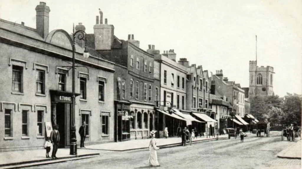
Transport transformed Barnet by connecting previously separate settlements with London and encouraging housing construction near stations and routes. Railways, trams and Underground services reduced travel barriers, strengthened town centres and helped convert Barnet from dispersed settlements into an integrated suburban area.
Transport infrastructure has consistently influenced where Barnet developed. Before railways, Chipping Barnet benefited from its position on an important north-south route. Barnet Council records state that the High Road became a turnpike in 1712 and that the town had 25 coaching inns by 1756.
Railway development changed this pattern. Barnet Station opened in 1850 and was later known as New Barnet Station. High Barnet and Totteridge and Whetstone stations followed in 1872. These connections encouraged suburban roads, particularly around New Barnet and Brunswick Park.
The affordability and speed of travel remained important. Barnet Council notes that expensive railway fares initially restricted the effect of railways in some locations. East Barnet, Arkley and Mays Lane retained stronger rural characteristics during earlier stages of suburban development.
The 20th century brought stronger integration with London’s transport network. The 1907 tramline from Archway provided a direct connection into the capital. Underground railway development further changed the relationship between Barnet and central London.
This created a clear mechanism of urban growth. Better transport increased accessibility. Increased accessibility supported housing demand. New housing increased local populations. Larger populations supported shops, schools, services and community facilities.
The pattern remains visible today. High Barnet, Finchley Central, East Finchley, Hendon Central, Golders Green, Mill Hill East and other transport-connected districts have strong residential and commercial identities.
Transport therefore did more than move people. It helped determine the geography of modern Barnet.
Why did Barnet experience such rapid population growth?
Barnet’s population growth resulted from suburban housing expansion, improved transport, London’s outward growth and changing residential demand. Population increased particularly strongly during the 20th century, transforming Barnet from dispersed settlements into a large urban borough within Greater London.
Barnet’s population history demonstrates the scale of urbanisation. Historical census data compiled by the Great Britain Historical GIS and the University of Portsmouth records substantial population increases during the 20th century. The Barnet District series records a population increase of 81,023 between 1921 and 1931.
The boundaries used for historical statistics changed over time, so direct comparisons between every census year require care. Barnet Council specifically notes that historical boundaries differed between civil parishes, urban districts and later borough structures.
Even with those boundary changes, the overall trend is clear. Housing development expanded across the district during the interwar period and continued after the Second World War.
Suburbanisation was particularly significant. London experienced major outward growth during the early and mid-20th centuries as improved transport allowed households to live farther from central employment areas.
Barnet became one of the northern suburban zones absorbing this growth. New housing estates, semi-detached homes, flats and maisonettes replaced or surrounded earlier agricultural land and smaller settlements.
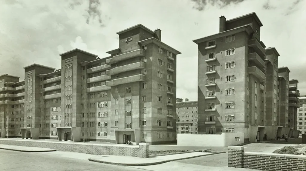
Post-war development introduced another phase of growth. Housing shortages, reconstruction and public-sector building programmes encouraged new residential schemes. Barnet Civic News from 1966 records that the newly formed borough inherited numerous housing projects, including point blocks, low-rise houses, maisonettes, flats and accommodation for older residents.
Population growth continued into the 21st century. The Office for National Statistics recorded 389,300 residents in Barnet at the 2021 Census, compared with approximately 356,400 in 2011. That represents a 9.2% increase, exceeding the London increase of 7.7% during the same period.
Barnet therefore changed from a growing suburban district into a major London population centre.
How did housing change Barnet after the Second World War?
Post-war housing changed Barnet through large-scale construction, redevelopment and diversification of residential types. Traditional houses were joined by flats, maisonettes, tower blocks and purpose-built estates, creating denser neighbourhoods while established suburban streets remained a defining feature.
Housing is one of the clearest physical indicators of Barnet’s transformation.
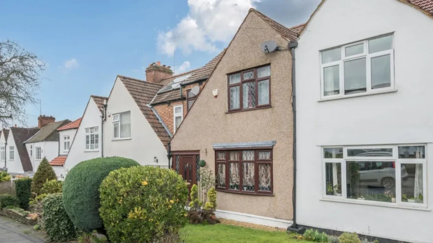
Before the Second World War, suburban expansion produced large numbers of houses around railway and tram routes. Many neighbourhoods developed with low-rise residential streets, gardens and local shopping parades.
After 1945, housing policy introduced different forms of development. The new London Borough of Barnet inherited housing programmes from predecessor authorities when it was created in 1965. Contemporary council records describe projects involving point blocks of up to 16 storeys, low-rise houses, maisonettes, medium-rise flats and one-room flats for older residents.
This produced greater residential variety.
High-density blocks provided more homes on smaller areas of land. Low-rise estates provided planned residential communities. Existing Victorian and Edwardian housing continued to serve established neighbourhoods.
Housing development also changed local infrastructure. Larger residential populations required schools, health facilities, roads, parks, shops and public services.
During the later 20th century, the emphasis increasingly shifted towards maintaining existing neighbourhoods and redeveloping previously developed land. Barnet’s planning characterisation study identifies brownfield redevelopment as an important part of later growth while recognising the protection of Green Belt, Metropolitan Open Land and other open spaces.
This explains why modern Barnet combines dense development with extensive open landscapes.
The borough’s residential identity is therefore layered. A visitor can encounter Victorian terraces, Edwardian suburban houses, interwar estates, post-war flats and contemporary developments within relatively short distances.
That mixture is a direct result of a century of changing housing needs.
How did local government reshape Barnet?
Local government reshaped Barnet most dramatically in 1965, when the London Borough of Barnet was created through reorganisation. Several former authorities were combined, giving the area a single administrative structure within the new Greater London system.
The modern borough was established on 1 April 1965. Barnet Council states that the new authority brought together areas previously administered by the municipal boroughs of Finchley and Hendon, Friern Barnet Urban District, East Barnet Urban District and Barnet Urban District.
This was more than a change of name.
Before 1965, local services were organised through several authorities. Each had responsibilities for housing, roads, planning, education and other municipal functions within its own boundaries.
The creation of the London Borough of Barnet placed these responsibilities under a larger metropolitan authority.
The change occurred as part of the wider creation of Greater London. The new administrative structure recognised the increasingly interconnected nature of London’s suburban communities.
The 1965 reorganisation also created a larger planning area. This mattered because urban growth increasingly crossed historic boundaries.
Housing, transport and land-use decisions could be considered across a broader geographical area. This strengthened the ability to coordinate services across districts that had previously operated under separate councils.
The borough’s creation is therefore an essential milestone in understanding modern Barnet. Its present identity reflects both historic local communities and the administrative framework established in the 1960s.
How did Barnet’s town centres change during the last century?
Barnet’s town centres evolved from traditional market and shopping settlements into multifunctional suburban centres containing retail, food, services, offices, community facilities and transport connections. Their historic identities remain visible alongside modern commercial and residential uses.
Chipping Barnet provides one of the clearest examples of historical continuity. Its development was closely associated with the High Road, coaching traffic and the traditional market-town economy.
The decline of coaching reduced the importance of the old transport system. Railways and later Underground services created a different economic geography.
Other centres developed alongside residential growth. Finchley, Hendon, Golders Green, New Barnet and East Finchley expanded their commercial functions as populations increased.
Local shopping became important within suburban neighbourhoods. Shops were positioned along major roads and around transport nodes, allowing residents to obtain everyday goods without travelling into central London.
Over the decades, the function of these centres broadened. Retail remained important, but restaurants, cafés, professional services, community facilities and leisure businesses became increasingly prominent.
Town centres also experienced changes in building form. Older premises were refurbished, extended or replaced. Residential development increasingly appeared above or alongside commercial premises.
The result is a multi-centre borough rather than a single dominant town centre.
For visitors, this means Barnet’s urban character changes from district to district. High Barnet has a strong historic identity. Golders Green has a distinctive metropolitan commercial environment. Hendon contains major residential, educational and employment areas. Finchley includes several established commercial centres.
These differences reflect the layered growth of the borough rather than a single development programme.
How did Barnet’s green spaces survive urban expansion?
Barnet retained substantial green infrastructure despite intensive urban growth because planning policies protected Green Belt land, Metropolitan Open Land, parks and other open spaces. These areas now form an important contrast with dense residential neighbourhoods and major transport corridors.
Urban expansion did not eliminate Barnet’s open landscapes.
The borough’s planning history includes continued protection of Green Belt and other forms of open land. Barnet’s characterisation study states that later expansion is largely constrained to redevelopment of brownfield sites while the council protects Green Belt, Metropolitan Open Land and other green spaces.
This policy has shaped the modern urban form.
Instead of continuous development across the entire northern edge of London, built-up neighbourhoods coexist with protected landscapes.
Areas around Arkley, Totteridge and other northern districts retain a different physical character from dense areas around Hendon, Finchley and Golders Green.
Parks and open spaces also provide recreation for residents and visitors. They support walking, informal leisure and ecological functions while contributing to the visual identity of the borough.
The survival of open land is especially significant because Barnet has become increasingly densely populated.
The 2021 Census recorded approximately 389,300 residents. ONS calculated that Barnet had around 32 people per football-pitch-sized area in 2021, compared with 29.3 in 2011, placing the borough within the top 15% of the most densely populated English local authority areas at that census.
The coexistence of density and open space is therefore a defining feature of modern Barnet.
How has Barnet’s population become more diverse?
Barnet’s population has become more diverse as London expanded and migration reshaped its communities. The modern borough contains residents with varied national, cultural, linguistic and religious backgrounds, creating neighbourhoods with distinct community identities.
Population change in Barnet has not been limited to numerical growth.
The 2021 Census provides detailed information on demographic characteristics, migration, ethnic groups, national identity, languages and religion. Barnet Council’s Census 2021 programme identifies these subjects as key areas of local demographic analysis.
This diversity is visible in the borough’s neighbourhoods, businesses, food markets, community organisations, places of worship and cultural activities.
Golders Green, Hendon, Finchley, Colindale and other districts have developed distinctive community profiles. These identities contribute to the borough’s contemporary social geography.
The population is also changing by age.
ONS reported that Barnet’s median age increased from 35 in 2011 to 37 in 2021. The number of residents aged 50 to 64 increased by more than 12,300, representing a 22.3% rise. At the same time, the number of residents aged 25 to 34 decreased by around 3,400, or 5.5%.
These changes affect housing demand, transport needs, health services, education and local employment.
Barnet’s demographic development therefore represents both population growth and structural change.
What happened to Barnet’s economy and employment?
Barnet’s economy shifted from traditional market-town, manufacturing and local-service activities towards a diversified metropolitan economy. Modern employment includes professional services, retail, education, healthcare, hospitality, construction and businesses connected to London’s wider economy.
Economic change followed population and transport growth.
Historic Barnet relied strongly on market activity, coaching traffic, local trade and services. As railways and suburban transport improved, Barnet became increasingly integrated with London’s employment market.
Many residents could live in Barnet while travelling to employment elsewhere in London.
This commuter relationship influenced the development of residential neighbourhoods and local businesses. Shops, cafés, schools, professional services and other facilities expanded to serve growing communities.
Hendon developed a significant employment and institutional role. Finchley and Golders Green developed strong commercial centres. Other districts combined residential areas with smaller employment clusters.
The modern economy is more diversified than the economy of a century ago.
Digital connectivity has also changed how people use local areas. Work is no longer defined entirely by traditional offices and factories. Cafés, libraries, co-working environments and flexible workspaces increasingly support residents and visitors who need temporary work facilities.
For domestic business travellers, this creates a different relationship with Barnet. The borough functions both as a residential area and as part of London’s wider economic geography.
Economic transformation therefore reinforced Barnet’s transition from a collection of local settlements into a metropolitan borough.
How did Barnet’s physical landscape change?
Barnet’s physical landscape changed through the gradual replacement of agricultural and undeveloped land with housing, roads, schools, commercial buildings and transport infrastructure. Historic streets and settlements survived, creating a layered urban landscape rather than complete redevelopment.
The most significant physical change was outward suburbanisation.
During the early 20th century, development expanded from established centres and transport corridors. New residential streets appeared around railway stations and tram routes.
Interwar development accelerated this process.
Post-war construction added larger housing estates, flats, schools and public facilities. Roads were upgraded to support increasing car ownership and population movement.
The landscape consequently became more built-up, but not uniformly urban.
Historic buildings remained embedded within newer development. Churches, civic buildings, market structures, older houses and traditional street patterns provide evidence of earlier phases.
Barnet’s modern character therefore reflects several development periods.
A Victorian transport route can sit beside an Edwardian residential street. A post-war housing estate can stand close to a historic village centre. Contemporary apartment development can occupy land previously used for industrial or low-density purposes.
This layered structure is one of the most important ways to understand Barnet’s last century.
As you explore the modern borough, you are crossing land shaped by centuries of settlement. Read the full to understand its origins.
How has Barnet changed since the 1960s?
Since the 1960s, Barnet has become larger, denser and more economically and socially diverse while retaining established suburban districts and protected open spaces. Population growth, redevelopment, changing transport patterns and metropolitan integration have continued to reshape the borough.
The creation of the London Borough of Barnet in 1965 provided the administrative framework for the modern period.
The borough inherited a substantial programme of housing, education and public-building projects. Barnet’s 1966 civic records describe numerous schemes already underway when the new authority was formed.
Later decades brought further changes.
Car ownership increased. Roads became more important for local mobility. Shopping patterns changed as residents gained access to larger retail centres and new forms of consumer services.
At the same time, Underground and rail services remained central to Barnet’s relationship with the rest of London.
Housing development continued, but planning constraints increasingly emphasised the reuse of previously developed land.
The borough also experienced continuing demographic change.
Between 2011 and 2021, Barnet’s population increased by approximately 33,000 people. The 9.2% rise took the population to around 389,300, making Barnet the second-largest London borough by population according to the council’s Census 2021 briefing.
This growth places pressure on housing, transport, education, health provision and public spaces.
It also supports local commerce and services.
Modern Barnet is therefore not simply a larger version of the Barnet of 1926. It operates as a complex metropolitan borough with multiple town centres, major transport links, extensive residential districts and protected open landscapes.
What does Barnet’s transformation mean for visitors today?
Barnet’s century of development gives visitors access to historic market-town character, suburban architecture, transport heritage, green spaces, cultural diversity and modern commercial districts within one north London borough. Its layered landscape makes different neighbourhoods useful for different visitor interests.
Visitors interested in history can explore Chipping Barnet and High Barnet, where older streets and buildings preserve evidence of the area’s market-town development.
Transport enthusiasts can examine the influence of railway and Underground expansion on neighbourhood form.
Architecture-focused visitors can compare Victorian and Edwardian houses with interwar estates and post-war housing.
Green-space visitors can experience the contrast between built-up neighbourhoods and protected landscapes.
Food and culture provide another dimension. Modern Barnet contains a wide range of independent businesses and community institutions reflecting its diverse population.
For digital nomads and business travellers, the borough’s transport connections provide access to central London while its local centres offer everyday services outside the capital’s busiest core.
The most useful way to experience Barnet is by district. High Barnet, New Barnet, Finchley, Hendon, Golders Green, Mill Hill, East Finchley and other neighbourhoods developed under different historical circumstances.
This diversity is the direct product of the last century.
Explore More Area Guide
Historic Churches to Visit in Barnet: Heritage Guide 2026
Best Photography Locations in Barnet: Scenic Spots 2026
What will shape Barnet’s next stage of development?
Barnet’s future development is shaped by population growth, housing demand, transport capacity, brownfield redevelopment, environmental protection and changing patterns of work. The central challenge is accommodating metropolitan growth while retaining historic character, established communities and valuable open spaces.
Barnet enters its next phase with a substantially larger population than it had a century ago.
The 2021 Census recorded approximately 389,300 residents, compared with much smaller populations across the separate settlements that existed before the borough was formed. ONS data also identifies continuing demographic change, including an ageing population profile.
Housing remains a central planning issue.
Further development must respond to population needs while respecting existing neighbourhood character and protected land. Barnet’s planning history demonstrates the importance of brownfield redevelopment where available land is constrained by Green Belt and other protected spaces.
Transport will remain equally important.
The original suburban expansion was driven by improved connections to London. Modern development continues to depend on reliable rail, Underground, bus, road and active-travel networks.
Climate and environmental considerations also have greater importance than they did in the early 20th century. Parks, trees, open land and ecological corridors contribute to the borough’s environmental resilience.
Barnet’s next century will therefore continue the same fundamental process that shaped the last one: balancing growth with the protection of established places and landscapes.
Why is Barnet’s 100-year transformation important?
Barnet’s transformation demonstrates how transport, housing, population growth, local government and planning collectively reshape an urban area. Its journey from dispersed suburban settlements to a major London borough explains the distinctive combination of historic centres, modern neighbourhoods and protected open spaces visible today.
The last century changed almost every aspect of Barnet.
Transport reduced the distance between northern communities and central London. Housing expansion transformed farmland and open land into suburbs. Population growth increased demand for services and infrastructure. The 1965 local-government reorganisation created the modern borough.
Yet Barnet did not lose its historical structure completely.
Historic settlements survived. Older roads remained important. Town centres retained distinctive identities. Open spaces continued to shape the borough’s northern and western edges.
The result is a layered urban landscape.
For residents, this history explains why different parts of Barnet have distinct architectural, cultural and commercial identities. For tourists, it provides a framework for understanding what they see while travelling through the borough.
For digital nomads and business travellers, it explains why Barnet combines metropolitan connectivity with neighbourhood-scale amenities.
Barnet’s development over the last 100 years is therefore best understood as continuous urban evolution rather than a single transformation. The borough expanded, densified and diversified while retaining important evidence of earlier periods.
That combination defines modern Barnet and provides the foundation for its continued development within north London.
How has Barnet changed over the last 100 years?
Barnet changed from a collection of suburban settlements and open landscapes into a large, densely populated London borough. Transport expansion, housing development, population growth, planning policies and the creation of the London Borough of Barnet in 1965 drove this transformation.