Barnet’s High Street is the historic commercial spine of Chipping Barnet, also known as High Barnet, in the London Borough of Barnet. Its development was shaped by medieval markets, the Great North Road, coaching traffic, road improvements, railways, suburban growth and later retail redevelopment.
- When did Barnet High Street first become a town centre?
- Why did Barnet’s medieval market shape the High Street?
- How did the Great North Road change Barnet High Street?
- Why was Barnet High Street rebuilt and improved in the nineteenth century?
- What happened to Barnet Market as the High Street expanded?
- How did Victorian development change Barnet High Street?
- How did railways change Barnet High Street and its surrounding town?
- Which historic buildings still explain the development of Barnet High Street?
- When did modern retail development begin on Barnet High Street?
- How does conservation protect Barnet High Street’s historic character?
- How has Barnet High Street developed into its present-day town centre?
- Why does the historical development of Barnet High Street still matter today?
The modern High Street still reflects these layers. The market tradition survives, historic buildings remain around St John the Baptist Church, and later shopping developments sit alongside older commercial premises. Understanding this evolution explains why Barnet High Street has a different character from newer retail centres elsewhere in North London.
Barnet Council identifies Chipping Barnet as a historic town centre on the edge of London. The centre contains Barnet Market, The Spires shopping centre, Chipping Barnet Library, restaurants, cafés, bars and independent shops across more than 38,310 square metres of retail space.
When did Barnet High Street first become a town centre?
Barnet High Street developed as a town centre because a major medieval route from London to St Albans passed through the settlement, creating a strategic location for trade, travel, markets and services around the road junction.
Barnet existed before the Norman Conquest, although the settlement does not appear in the Domesday Survey. The earlier centre was associated with East Barnet, but its importance declined as settlement activity shifted towards the route running north from London towards St Albans.
By the 11th century, the northbound route had become important enough to encourage a settlement around it. This route later formed part of the Great North Road, one of the principal historic routes between London and northern England.
Barnet’s position was particularly significant because it stood on high ground. The route connected London with St Albans and continued towards destinations further north. The Wood Street Conservation Area appraisal describes the road as an important route dating from the late 11th or early 12th century.
The High Street therefore did not begin primarily as a modern shopping street. Its original importance came from movement and exchange. Travellers needed food, accommodation, animal services, markets and other facilities. These requirements encouraged permanent commercial activity.
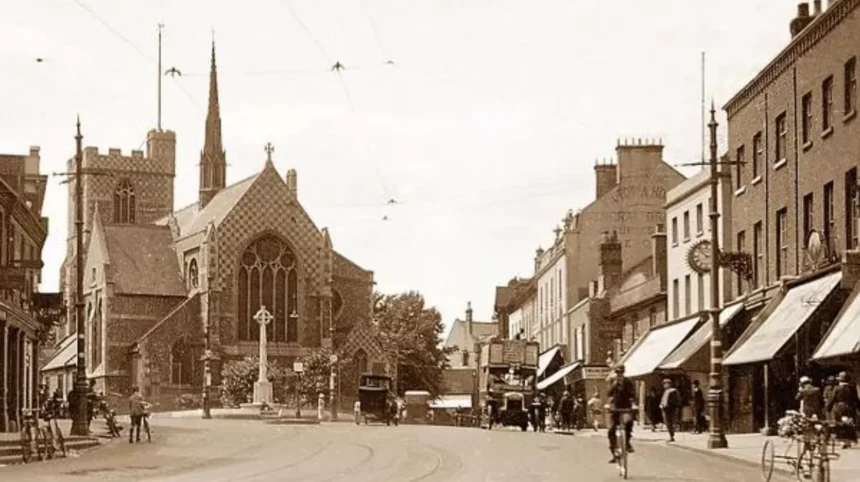
The junction around Wood Street and St John the Baptist Church became the historic focus. The market developed close to this junction, creating a commercial centre that continued to influence the physical form of Barnet High Street.
For visitors today, the historic street pattern is best understood as the product of this combination of route, market and settlement.
Why did Barnet’s medieval market shape the High Street?
Barnet’s medieval market established the High Street as a place of regular trade, with its location near Wood Street and the Great North Road encouraging livestock dealing, food trading, commercial services and movement between London and northern settlements.
The word “Chipping” refers to a market. Chipping Barnet therefore preserves a direct linguistic connection with its commercial history. Barnet Council records the market as existing in various forms and locations since at least the 12th century.
King John granted Barnet a Royal Charter in August 1199. The charter formalised the market tradition and strengthened Barnet’s position as a commercial settlement.
The original market was located around the point where Wood Street divided from the High Street. This location placed trading activity directly beside the main north-south route.
The market traded goods including corn, wool and pottery. By the 16th century, livestock became particularly important. Barnet’s location was suitable for cattle movement because roads connected it with areas used for holding and moving livestock.
By the late Tudor period, Barnet’s market had become closely connected with London’s meat supply. London butchers travelled to Barnet to purchase cattle. Animals were kept on nearby farms before being brought into London when required.
This commercial activity had a direct effect on the High Street. Markets required space, access and supporting businesses. Inns, shops, yards and services developed around the movement of traders and travellers.
The market also gave Barnet a recurring reason for people to travel into the town. The High Street was therefore both a transport corridor and a destination.
This dual function became one of the defining characteristics of Barnet’s historic town centre.
How did the Great North Road change Barnet High Street?
The Great North Road transformed Barnet High Street into a major coaching and transport corridor, bringing inns, travellers, traders and services into the town while also creating congestion that eventually required major road engineering in the early nineteenth century.
The road through Barnet formed part of the wider Great North Road network. It connected London with St Albans and routes leading towards northern England.
Barnet’s position on a ridge made it a useful stopping point. The town was approximately a day’s ride from London and conveniently positioned towards St Albans.
Road travel intensified during the coaching era. The High Street developed a strong concentration of inns and commercial premises serving coaches and their passengers.
Barnet Council records that the High Road became a turnpike in 1712. A turnpike was a road on which users paid a toll to help fund maintenance and improvement.
By 1756, Barnet had 25 inns where coaches could change horses. This figure demonstrates the scale of the town’s role in the road transport system.
The coaching economy influenced the appearance and function of the High Street. Inns provided accommodation and refreshments. Stables supported horses. Shops supplied travellers and residents. Public houses became important social and commercial institutions.
The road itself also created problems.
At the section around St John the Baptist Church, the route became narrow. The resulting bottleneck was known locally as “the squeeze”. Shops stood on an island in the road in front of the church. These premises were known as Middle Row and formed part of the original market area.
The market and road therefore competed for the same physical space.
That conflict eventually became an important reason for changing the High Street’s layout.
Why was Barnet High Street rebuilt and improved in the nineteenth century?
Barnet High Street was reshaped during the nineteenth century because the original road was steep and congested, while coaching, military and commercial traffic required a more efficient route through the town. Road improvements changed movement without removing the historic town-centre function.
Until the 1820s, the Great North Road entered Barnet through Victoria Lane before descending towards Underhill. The route was steep and difficult for heavy traffic.
From 1818, a straighter road was constructed on a raised embankment. The new route reduced the gradient and improved movement through the town. Barnet Council states that the improved road also allowed military forces to move more quickly towards the important port of Holyhead and Ireland.
Further road changes followed. Between 1818 and 1823, the main route was improved and the incline was reduced. In 1828, a new road towards St Albans created a shorter connection to that town.
These changes altered the relationship between the High Street and the surrounding streets.
New streets were laid out during the 1820s and 1830s. Moxon Street was described as new in 1825, while Union Street was built in 1837. These streets expanded the urban structure around the High Street.
Union Street became particularly important for local administration. Barnet Town Hall occupied premises there from 1889 to 1912. Schools also developed along Moxon Street and Union Street during the nineteenth century.
The town was therefore expanding beyond the immediate road frontage.
The High Street remained the commercial core, while secondary streets provided space for housing, education, administration and other urban functions.
What happened to Barnet Market as the High Street expanded?
Barnet Market moved away from its original position beside St John the Baptist Church as traffic increased, eventually developing into a more general market after the decline of its historic livestock function and changes in the town’s transport economy.
By the 17th century, Barnet’s livestock market had lost some of its earlier dominance. Smithfield Market in London and Hog Market at Finchley became important competitors.
The market’s location also became increasingly problematic.
During the 1830s, the market was described as insignificant while its presence contributed to congestion for coaches travelling along the High Street. The squeeze beside St John the Baptist Church became a recognised traffic problem.
In 1851, the market moved to New Road. It closed at that location between 1855 and 1866 before being re-established in 1869 near the Green Man inn by William Kemp.
A separate general market known as the Poor Man’s Market operated around Mary Payne’s Place, near present-day Bath Place. It continued until the 1950s.
The last cattle auction in the main market took place in August 1959. After this point, the market became more general in character.
The market’s evolution demonstrates an important change in Barnet High Street.
The town moved from an economy strongly connected with livestock and long-distance road transport towards a retail and service economy serving a growing suburban population.
Yet the market tradition survived.
Barnet Council states that Barnet Market still operates today and identifies it as one of the defining features of Chipping Barnet town centre.
How did Victorian development change Barnet High Street?
Victorian development strengthened Barnet High Street as a permanent urban centre by adding commercial buildings, houses, institutions, churches, streets and transport connections around the older medieval road and market structure.
The Victorian period produced a more recognisable urban town centre.
Older coaching functions declined, while shops and services became increasingly important. The High Street had already served as Barnet’s principal shopping area since at least the 18th century.
The surrounding street network expanded.
Salisbury Road, Strafford Road, Alston Road and Stapleton Road had been laid out by 1881. New buildings supported a growing local population and diversified economy.
Commercial activity also developed through local businesses.
John James Cowing opened a printing business on the High Street in 1805. His sons later established The Barnet Press in 1859 using the family printing business. The newspaper eventually left Barnet in 1986.
This type of business demonstrates that the High Street was not simply a place for shops. It supported professional, publishing and service activities alongside retail.
Religious buildings also contributed to the historic streetscape.
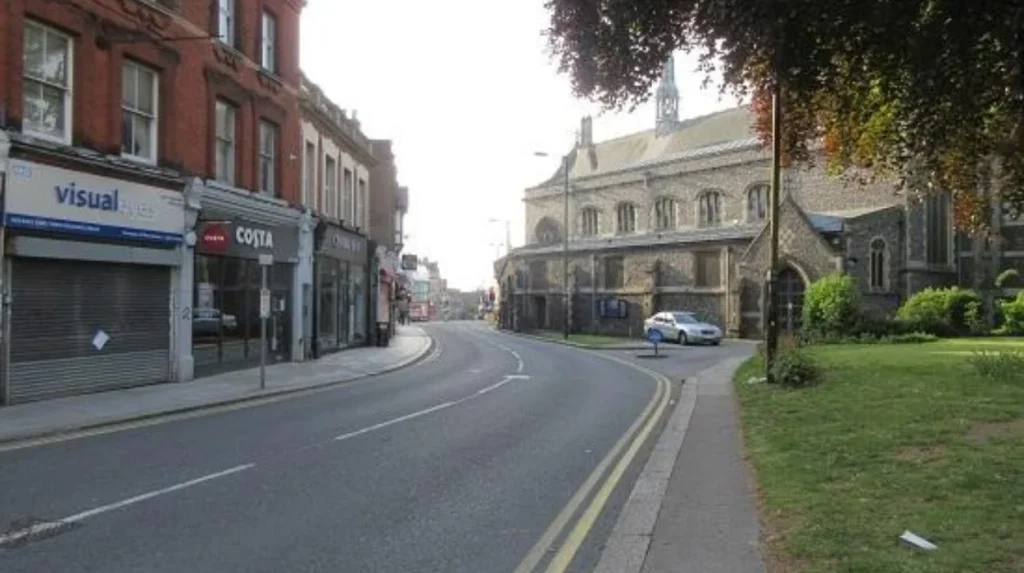
St John the Baptist Church occupies the key historic junction. Historic England identifies the church as a Grade I listed building. Its surviving fabric includes medieval elements, including a mid-12th-century north aisle and later medieval additions. The building was restored in 1875.
The church therefore provides a direct architectural connection between the medieval settlement and the Victorian town.
The wider High Street also acquired Victorian commercial and residential buildings. The northern end of Chipping Barnet High Street forms part of the Monken Hadley Conservation Area, which includes predominantly Victorian commercial and residential properties alongside older Georgian buildings.
These surviving structures explain much of the historic character visible today.
How did railways change Barnet High Street and its surrounding town?
Railways changed Barnet by reducing the dominance of long-distance coaching, improving access to London and encouraging suburban expansion, although expensive fares initially limited the speed of residential growth around High Barnet and nearby districts.
Rail transport introduced a different economic relationship with London.
Barnet Station opened in 1850 and was later known as New Barnet Station. High Barnet station opened in 1872, alongside Totteridge and Whetstone station. These railway connections encouraged suburban development, particularly around New Barnet.
The railway also affected the traditional coaching economy.
Barnet’s importance as a coach stop had already begun to decline before the railway fully changed local travel. The road toll was removed in 1862, further marking the end of the turnpike era.
Rail access did not immediately transform every part of Barnet. Fares between Barnet and London were relatively expensive, so some areas remained rural for longer.
The major suburban transformation accelerated in the early twentieth century.
A tramline from Archway reached Barnet in March 1907. The development of tram and underground connections helped suburban streets expand more rapidly.
This changed the role of the High Street.
Instead of depending mainly on long-distance travellers, the town centre increasingly served local residents. Shops, services, entertainment venues and community facilities became more important.
The High Street thus became a suburban town centre within the expanding London metropolitan area.
Which historic buildings still explain the development of Barnet High Street?
Historic buildings around Barnet High Street preserve evidence of its medieval religious centre, coaching era, Victorian expansion and twentieth-century commercial change, allowing visitors to read the town’s development through surviving streets, façades and landmark structures.
The most important historic landmark is St John the Baptist Church.
Historic England lists the church at Grade I. Its fabric incorporates medieval construction dating from the 12th and 13th centuries, while later restoration changed parts of the building during the 19th century.
The church’s position is equally important as its architecture. It stands at the historic junction where the market and major roads converged.
The High Street also retains evidence of the coaching period. Historic inns and older commercial buildings reflect the period when travellers and coaches formed a major part of the town’s economy.
Wood Street is another important element. Barnet Council’s Wood Street Conservation Area includes historic shops around Barnet Hill and St John’s Church, as well as Union Street and historic buildings extending westwards along Wood Street.
The conservation area was designated in 1969 and extended in 1979. Its purpose is to protect an area with special architectural and historic character.
As you explore the modern site, you are crossing land with a deep heritage. Read about the full to understand its origins.
For visitors, this means a walk along the High Street can be treated as a historical route rather than simply a shopping trip.
When did modern retail development begin on Barnet High Street?
Modern retail development accelerated during the twentieth century as traditional markets and coaching businesses gave way to supermarkets, cinemas, purpose-built retail facilities and later shopping centres serving a suburban population connected with London.
Entertainment became part of the High Street economy during the early twentieth century.
The Cinema Palace opened on the High Street in 1912. It was renamed Barnet Cinema in 1926 and closed in 1959. A supermarket replaced the cinema site.
This change illustrates the growing importance of modern consumer retail.
The High Street was no longer primarily defined by coaching inns and livestock trading. Retail premises increasingly served everyday household needs.
The wider town centre also developed new community infrastructure. Chipping Barnet Library opened in 1991.
The biggest modern intervention was The Spires.
The Spires shopping centre opened in 1989. It was constructed on the site of a former Methodist chapel and Barnet’s old militia barracks. The entrance retained the front of the former 1891 Methodist chapel.
This approach created a direct physical connection between historic architecture and modern retail development.
The High Street therefore did not develop through complete replacement. Instead, different periods were incorporated into the same commercial environment.
How does conservation protect Barnet High Street’s historic character?
Conservation policy protects significant historic buildings, streetscapes and architectural character while allowing Chipping Barnet to continue functioning as a modern town centre with shops, services, leisure uses, community facilities and transport connections.
Conservation areas are places recognised for special architectural or historic interest. Barnet Council identifies Wood Street and Monken Hadley among the borough’s designated conservation areas.
Wood Street is particularly relevant to the High Street because it includes the historic commercial area around St John the Baptist Church and Barnet Hill.
Conservation controls help retain the physical evidence of earlier periods.
Listed buildings receive statutory protection under the Planning (Listed Buildings and Conservation Areas) Act 1990. St John the Baptist Church is one of the principal protected historic structures associated with the High Street.
Conservation does not mean that the town centre stops changing.
Barnet Council’s planning framework recognises the need for improved public spaces, pedestrian and cycle connections, transport, building quality, employment, residential uses, leisure and retail activity.
This creates a continuing balance between preservation and adaptation.
The historic character of Barnet High Street is therefore maintained through the protection of significant structures while the commercial centre continues to evolve.
Explore More Area Guide
Why Did Barnet Become an Important Market Town?
Barnet Name Origin: The Story Behind Barnet, London
How has Barnet High Street developed into its present-day town centre?
Barnet High Street developed through successive economic phases: medieval market trading, Great North Road travel, coaching, Victorian urban growth, railway-led suburbanisation, twentieth-century retail and modern town-centre planning, with each phase leaving physical evidence behind.
The present High Street is the result of cumulative development rather than one redevelopment project.
Its medieval identity survives in the name Chipping Barnet, the market tradition and the position of St John the Baptist Church.
Its coaching history survives in the historic road alignment, older commercial buildings and surviving town-centre architecture.
Its Victorian identity appears in commercial façades, residential buildings, institutions and the expanded street network.
Its suburban identity reflects the arrival of railways, trams and improved connections with London.
Its modern retail identity is represented by Barnet Market, The Spires, independent shops, cafés, restaurants, bars and community facilities. Barnet Council currently describes Chipping Barnet as a historic town centre with more than 38,310 square metres of retail space.
The market remains especially significant because it links the modern town directly with its medieval commercial origins.
The High Street’s development also explains why its character differs from purpose-built shopping districts. Historic routes, religious buildings, older commercial premises and modern retail uses occupy the same town-centre environment.
For tourists, this makes the High Street useful as a starting point for exploring Chipping Barnet’s wider heritage.
For residents, the same historic structure provides the setting for everyday shopping and community activity.
For digital nomads and business travellers, the present-day cafés, shops and services sit within a town centre shaped by more than eight centuries of commercial development.
Why does the historical development of Barnet High Street still matter today?
Barnet High Street’s history explains its present identity, from the market-based meaning of Chipping Barnet to the surviving medieval church, coaching-era route, Victorian buildings and modern retail centre, making historical development central to understanding the town today.
The most important point is that Barnet High Street developed because of movement and trade.
The medieval road created the settlement.
The market created a reason for regular commercial activity.
The Great North Road brought coaches and travellers.
The coaching era produced inns and services.
Road improvements changed the physical route.
Railways and trams connected Barnet more closely with London.
Suburbanisation created a larger local customer base.
Modern retail replaced many older economic functions while retaining the High Street’s role as the town centre.
The result is a layered urban landscape.
A visitor standing near St John the Baptist Church is close to the location of the medieval market. The same area later experienced coaching congestion, Victorian redevelopment, twentieth-century retail change and modern conservation policy.
Barnet’s future town-centre planning continues to recognise the importance of its historic character. The council’s planning framework focuses on long-term vitality, better public spaces, improved connections and a stronger mix of retail, residential, leisure, employment and community uses.
That approach reflects the fundamental pattern established centuries ago.
Barnet High Street remains a place where movement, commerce, community and heritage meet.
Its development is therefore not simply a story of old buildings being replaced by new shops. It is the continuing adaptation of a historic town centre to changing transport systems, economic conditions, population growth and patterns of urban life.
For anyone exploring North London, understanding this evolution provides the clearest explanation of why Chipping Barnet High Street looks and functions as it does today.
When did Barnet High Street first develop?
Barnet High Street developed as a settlement around the medieval route between London and St Albans. Its location encouraged trade, travel and market activity, establishing the foundations of the present town centre.