London’s expansion transformed Barnet from a collection of rural villages, market settlements and agricultural landscapes into an established part of Greater London. Population growth, railway construction, suburban housing, road development and changes in local government connected Barnet more closely to central London while reshaping its economy, transport network and built environment.
- What Was Barnet Like Before London Expanded Northwards?
- How Did Railway Construction Connect Barnet to London?
- How Did Suburban Housing Change Barnet’s Landscape?
- How Did the Creation of Greater London Transform Barnet in 1965?
- How Did Road Development Increase Barnet’s Integration with London?
- How Did Barnet’s Economy Change as London Expanded?
- How Did London’s Expansion Affect Barnet’s Green Spaces?
- How Did London’s Growth Shape Barnet’s Cultural and Community Identity?
- How Has Urban Expansion Influenced Housing and Public Services in Barnet?
- How Can Visitors Explore the Effects of London’s Expansion in Barnet Today?
- What Does Barnet’s Transformation Reveal About London’s Future Growth?
What Was Barnet Like Before London Expanded Northwards?
Before London expanded northwards, Barnet was characterised by market-town activity, farming, woodland, scattered settlements and country estates. Chipping Barnet served as an important commercial centre on the historic Great North Road, connecting rural communities with London and supporting travellers, livestock traders and local businesses.
Barnet developed around settlements that existed independently of London’s modern suburban growth. Chipping Barnet, also known as High Barnet, gained importance through its position on the Great North Road, a major route connecting London with towns and agricultural districts to the north.
The area’s economy depended on agriculture, livestock markets, coaching inns and trades that served residents and travellers. Farmers supplied food to nearby settlements, while blacksmiths, wheelwrights, stable workers and shopkeepers supported transport and commercial activity.
Other settlements developed their own identities. Finchley retained a strong connection to its historic villages and open land. Hendon combined agricultural activity with village life, while Edgware developed along an important north-western route. Totteridge and Mill Hill retained substantial rural characteristics, including fields, country houses and woodland.
These communities did not develop simultaneously or follow an identical pattern. Their different locations, road connections and land ownership shaped the pace of later urbanisation.
London’s growth gradually changed the economic value of land around these settlements. Fields and estates close to transport routes became increasingly attractive for housing, while established village centres provided the foundations for new shopping streets, public services and residential districts.
The historic character of Barnet remains visible in its high streets, conservation areas, churches, older buildings and surviving open spaces. These features explain how the modern borough developed from several distinct settlements rather than from a single, uniformly planned town.
How Did Railway Construction Connect Barnet to London?
Railway construction connected Barnet’s settlements to London’s employment centres and accelerated suburban development. Underground and mainline services made longer daily journeys practical, encouraged residential construction around stations and helped transform agricultural districts into commuter communities linked to central London.
Railways played a central role in the expansion of north London during the nineteenth and twentieth centuries. Before widespread motor transport, commuting from rural districts depended heavily on road travel, walking and slower public transport. Railway connections reduced journey times and increased the attractiveness of residential land outside central London.
The arrival of railway services in the wider Barnet area changed how people travelled to work, accessed education and used local commercial centres. Finchley, Hendon, Edgware and High Barnet became increasingly connected to London’s expanding transport network through different railway lines and development periods.
The Northern line became particularly important to Barnet’s suburban growth. Its branches connected districts including Finchley and High Barnet with other parts of north London and the central city. Underground access helped establish residential areas where households could live farther from their workplaces without losing convenient access to London.
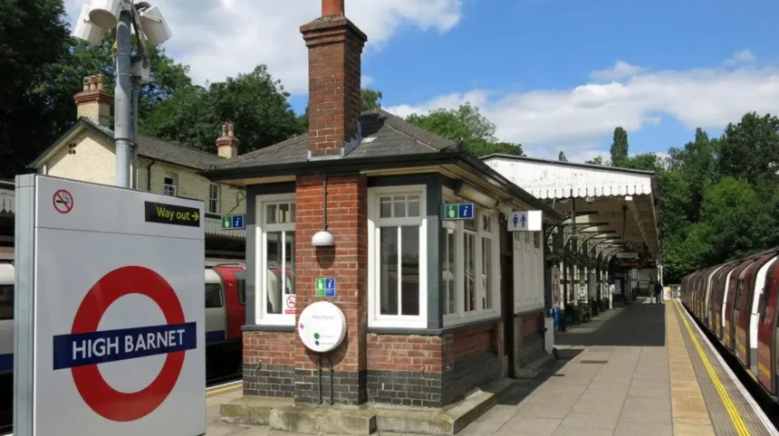
High Barnet Underground station opened in 1940, extending Northern line services to the town. Its arrival strengthened the area’s connection to central London and supported the continued development of surrounding residential neighbourhoods.
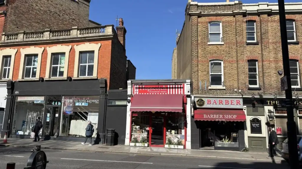
The railway effect extended beyond passenger journeys. Stations encouraged shops, cafés, offices and other businesses to cluster around transport hubs. Residential developers also targeted land within walking distance of stations because access to reliable transport made new housing more attractive.
Hendon and Mill Hill developed through their own combination of railway access, road connections, institutions and housing expansion. Their development illustrates that Barnet’s integration into London depended on several transport corridors rather than a single railway project.
Modern visitors can still trace this transformation by comparing station-centred shopping areas with older village centres and surviving green spaces. The contrast reveals how transport infrastructure influenced the distribution of housing and commercial activity across the borough.
How Did Suburban Housing Change Barnet’s Landscape?
Suburban housing transformed Barnet by replacing large areas of farmland and open land with residential streets, semi-detached houses, terraced homes and local shopping parades. Growth accelerated during the early twentieth century and expanded further after the Second World War as London’s housing needs increased.
The expansion of housing followed improvements in transport and rising demand for accommodation within commuting distance of London. Developers built new homes around railway stations, tram routes and major roads, creating residential districts that connected previously separated settlements.
The early twentieth century was especially significant. Barnet Council’s local history records that railway stations alone did not immediately produce extensive development everywhere. Expensive fares restricted growth in some districts, while the introduction of tram services from Archway in 1907 and subsequent Underground improvements encouraged further suburban expansion.
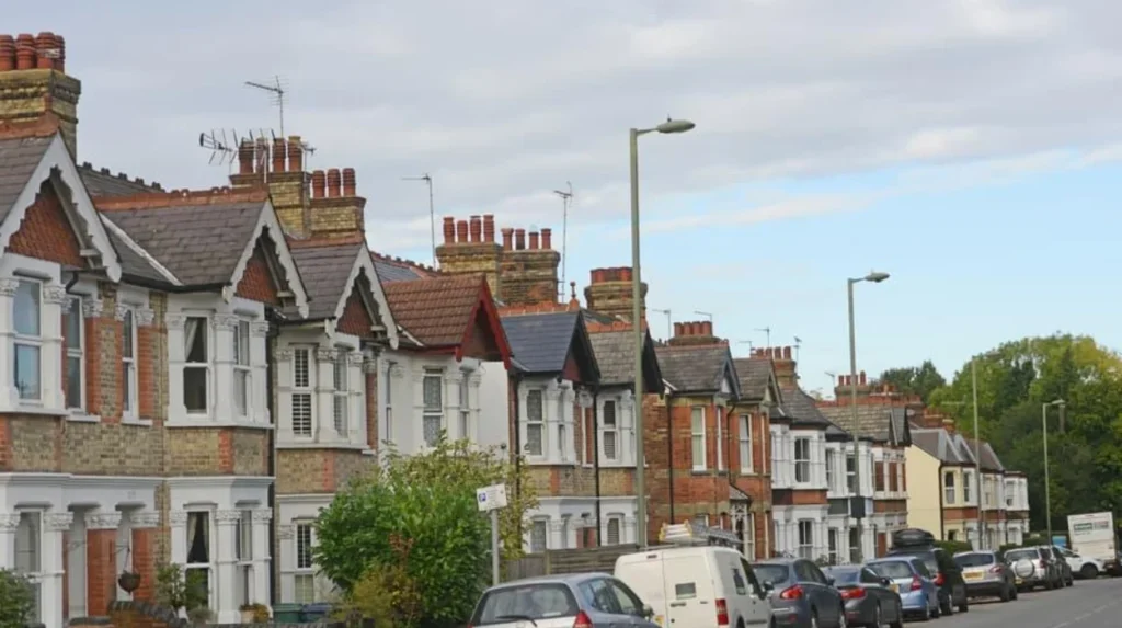
The resulting neighbourhoods included different housing forms. Victorian terraces appeared near established transport and commercial routes, while Edwardian and inter-war developments introduced more houses with gardens, wider residential streets and suburban layouts.
Brunswick Park, New Barnet, Finchley and Hendon illustrate different stages of this process. Their buildings reflect changes in construction methods, household expectations and access to transport. Some districts developed gradually around existing villages, while others expanded through larger housing schemes.
After the Second World War, housing demand remained a major influence on Barnet’s development. New residential estates and public infrastructure helped accommodate London’s growing population. Housing expansion also increased demand for schools, health services, shops, places of worship and recreational facilities.
The physical result was a more continuous suburban landscape. Previously distinct settlements became connected by housing, commercial streets and transport corridors, although parks, playing fields, farmland and protected green spaces continued to separate some neighbourhoods.
This transformation changed the meaning of distance. Residents increasingly travelled to work in London while using neighbourhood centres for everyday shopping and services. Barnet became more closely integrated into the capital’s residential economy without losing all its village identities.
How Did the Creation of Greater London Transform Barnet in 1965?
The creation of the London Borough of Barnet on 1 April 1965 formally incorporated Barnet into Greater London. The new borough combined five former local authority areas, creating a unified administrative structure for planning, housing, education, public services and local infrastructure.
The London Government Act 1963 reorganised local government across the capital. Its implementation in 1965 created the London Borough of Barnet, bringing together the former boroughs of Finchley and Hendon and the urban districts of Barnet, East Barnet and Friern Barnet.
This change was more than a new name or boundary. It placed several communities within a single London borough, making Barnet part of the capital’s wider system of local government.
The new council took responsibility for a broad range of local services. These included education, housing-related functions, libraries, waste collection, social care and local planning responsibilities. Over time, the division of responsibilities between borough government and London-wide institutions changed, particularly following the abolition of the Greater London Council in 1986 and the establishment of the Greater London Authority in 2000.
Administrative integration also changed how Barnet was understood geographically. Rather than being treated solely as a collection of settlements on London’s northern edge, the borough became an established part of Greater London.
The new borough retained considerable internal diversity. Chipping Barnet and High Barnet maintained their historic town identities, while Finchley, Hendon, Edgware, Golders Green and other districts continued to function as distinct residential and commercial centres.
For visitors, the borough’s formation explains why a journey through Barnet passes through neighbourhoods with different architectural styles, street patterns and local histories. Their shared administrative identity developed later than many of the settlements themselves.
Barnet Council marked the borough’s sixtieth anniversary in 2025 through its Birth of a Borough exhibition, which documented the area’s incorporation into Greater London. The council’s local studies and archives service also preserves historical maps, photographs, newspapers and documents that help explain this transition.
How Did Road Development Increase Barnet’s Integration with London?
Road development strengthened Barnet’s connection to London by supporting commuting, freight transport, commercial activity and residential construction. Major routes, including the A1, A41 and North Circular Road, improved access across north London while increasing traffic and pressure on established neighbourhoods.
Barnet’s road network evolved from historic routes used by coaches, livestock traders and local farmers. The Great North Road was particularly important to Chipping Barnet, where coaching inns and commercial premises served travellers heading north from London.
The development of modern roads changed the function of these routes. Motor vehicles increased the distance people could travel for work and shopping, while improved road access made land attractive for housing, warehouses, industrial premises and retail development.
The A1 and A41 became important north London transport corridors. The North Circular Road also improved connections between districts and other parts of the capital, although its effects varied according to location and the availability of connecting roads.
Road access helped businesses distribute goods and reach customers across a wider area. It also supported the growth of shopping destinations outside central London, particularly where large sites offered space for extensive retail buildings and car parks.
However, greater road capacity brought additional challenges. Traffic congestion, road noise, air pollution and pedestrian safety became important planning concerns. Major roads also created physical barriers between residential neighbourhoods, making some local journeys less direct.
These effects illustrate a central feature of Barnet’s urban development: improved connections brought economic opportunities but also generated new infrastructure demands.
Today, road travel remains important for reaching Barnet’s residential districts, business areas and attractions. Visitors travelling by car need to consider congestion and parking, while those using public transport benefit from the borough’s network of railway, Underground and bus connections.
The relationship between roads and housing continues to shape planning decisions. New developments require assessments of transport capacity, pedestrian access and the effect of additional journeys on surrounding streets.
How Did Barnet’s Economy Change as London Expanded?
London’s expansion shifted Barnet’s economy from a stronger reliance on agriculture, livestock trading and coaching services towards a more diverse suburban economy. Retail, education, healthcare, professional services, construction and transport became increasingly important as residential populations grew.
Barnet’s historic economy served both local communities and travellers passing through the area. Markets, inns, workshops and agricultural businesses supported settlements that depended on rural production and road transport.
As housing expanded, the customer base for local businesses increased. New residents needed groceries, clothing, household goods, medical care, schools and other services. Shopping streets developed around established centres, while smaller parades served residential neighbourhoods.
Railway and road connections also changed employment patterns. More residents travelled to workplaces elsewhere in London, while businesses within Barnet served customers from surrounding districts. The borough increasingly functioned as both a residential area and a collection of local employment centres.
Cricklewood provides an example of the relationship between transport and industry. Barnet Council’s conservation-area history records that the arrival of the railway encouraged housing and factory construction. In 1892, George Furness opened the Imperial Dry Plate Company, which manufactured photographic materials. The area’s industrial and residential development subsequently became closely associated with railway infrastructure and major roads.
Retail development created another important economic shift. Brent Cross Shopping Centre opened in 1976, establishing a major shopping destination in north London. Its location and scale reflected the growth of car ownership, suburban purchasing power and demand for large retail facilities outside central London.
The economy continued to diversify as schools, universities, hospitals, offices and other employers expanded. Middlesex University’s Hendon campus, for example, contributes to the area’s educational and employment activity, while local high streets continue to support independent retailers, restaurants and service businesses.
Economic change has not eliminated Barnet’s local identity. Markets, traditional shopping streets and historic town centres remain important alongside modern retail and commercial developments.
For visitors, this variety creates opportunities to combine shopping, heritage exploration, cafés and green spaces within the same borough. For residents, the mix of local employment and access to London’s wider labour market remains a defining feature of suburban life.
How Did London’s Expansion Affect Barnet’s Green Spaces?
London’s expansion reduced some agricultural land and fragmented parts of Barnet’s rural landscape, but parks, woodland, commons and protected open spaces remain important features of the borough. Planning policies now balance housing growth with environmental protection, recreation and biodiversity.
Barnet’s suburban development did not replace every field or woodland. Large open spaces survived because of historic land ownership, public acquisition, recreational use and planning restrictions.
Hampstead Heath Extension, Mill Hill’s open landscapes, Totteridge’s rural surroundings and the wider green spaces around Barnet demonstrate the continued presence of natural and semi-rural environments within Greater London.
These spaces serve several functions. Parks provide opportunities for walking, exercise and informal recreation. Woodland and grassland support wildlife, while open landscapes help manage surface water and moderate local temperatures. Playing fields and public gardens also provide facilities for community activities.
The Green Belt is particularly relevant to Barnet’s development. London’s Metropolitan Green Belt is a planning designation designed to restrict urban sprawl and maintain separation between settlements. It influences where new housing and commercial development can take place.
Barnet’s planning framework identifies Green Belt, Metropolitan Open Land, conservation areas, employment areas and other designated spaces. These designations help guide development decisions and determine where particular forms of construction face additional restrictions.
The existence of protected land does not mean that every open space is permanently free from development pressure. Housing demand, transport projects, environmental objectives and infrastructure requirements continue to influence planning debates.
Historic England’s research into England’s suburbs also emphasises the importance of understanding suburban landscapes as part of the historic environment. Residential streets, gardens, public parks and deliberately preserved open spaces all contribute to the character of modern suburbs.
Visitors can experience this contrast by exploring an established shopping centre and then visiting a nearby park or conservation area. The change in landscape reveals how Barnet accommodates urban life alongside substantial areas of open land.
Green spaces also affect the borough’s future. As housing and transport requirements increase, the protection of accessible recreational areas and ecological networks remains a key consideration for planners and residents.
How Did London’s Growth Shape Barnet’s Cultural and Community Identity?
London’s growth brought new residents, institutions, businesses and cultural influences into Barnet, creating diverse communities across its historic towns and suburban neighbourhoods. Local identity developed through the interaction of older village traditions, newer housing estates, migration and connections with the wider capital.
Barnet’s communities did not lose their distinct identities when they became part of Greater London. Instead, established local centres continued to develop alongside new residential districts and changing populations.
Historic High Barnet retains a recognisable town-centre structure, with shops, older buildings and streets connected to its market-town history. Finchley contains several established centres, while Hendon combines residential neighbourhoods, educational institutions, commercial areas and historic sites.
These differences reflect the area’s uneven development. Some neighbourhoods expanded rapidly around transport links, while others retained older buildings and street patterns. New residents brought different occupations, household structures and cultural traditions, changing the character of local shopping streets and community facilities.
Schools, libraries, religious buildings, sports clubs and community organisations helped establish social connections as populations grew. These institutions also supported residents who moved into new housing developments and needed local services.
Migration contributed to the changing cultural landscape. As London expanded, Barnet attracted households from other parts of Britain and from overseas. This broader demographic change influenced local food businesses, places of worship, community events and commercial activity.
Barnet’s heritage remains visible in its historic buildings and public spaces. Local archives preserve documents and photographs that record changes to streets, buildings, transport and everyday life. The borough’s local studies collections provide an important resource for researching these changes.
For visitors, cultural exploration involves more than visiting a single landmark. Walking through High Barnet, Hendon or Finchley reveals different combinations of historic architecture, modern businesses, public institutions and residential streets.
Understanding this layered identity helps explain why Barnet feels like a collection of connected communities rather than one uniform suburb. London’s expansion brought these settlements into a common metropolitan framework without making their local histories identical.
How Has Urban Expansion Influenced Housing and Public Services in Barnet?
Urban expansion increased demand for homes, schools, healthcare, transport, utilities and public facilities across Barnet. Local authorities and infrastructure providers have responded through planning policies, regeneration schemes and investment intended to accommodate population growth while maintaining access to essential services.
Housing growth changes more than the number of buildings in an area. Every additional household generates demand for transport, education, healthcare, water, energy, waste collection and recreational facilities.
Barnet’s growth therefore requires coordination between housing developers, the borough council, transport providers, utility companies and public service organisations. New housing without adequate supporting infrastructure places pressure on existing facilities, while coordinated development creates opportunities to improve local services.
The borough’s Local Plan for 2021–2036 establishes a framework for development over a fifteen-year period. It works alongside the Mayor of London’s London Plan and other planning documents to guide decisions about housing, employment, town centres, transport and environmental protection.
Regeneration is an important part of this process. Barnet Council identifies Brent Cross Cricklewood as a major regeneration area involving the expansion and redevelopment of Brent Cross Shopping Centre, new homes and office space, road and bridge improvements, and additional railway infrastructure.
Brent Cross West station forms part of the wider transformation of this area. The station strengthens rail access and supports the development of a new urban district, linking transport investment with housing and employment opportunities.
Colindale and Mill Hill East also feature in the borough’s wider planning framework. Their development illustrates how housing growth, public transport, community facilities and local environmental considerations interact in different parts of Barnet.
These projects reflect a broader change in how suburban development is managed. Earlier growth frequently followed railway construction and private housing development. Contemporary regeneration increasingly involves formal masterplans, infrastructure commitments, environmental assessments and coordination between multiple public and private organisations.
The challenge is to accommodate new residents without losing the historic centres, open spaces and local services that make Barnet distinctive. Effective planning must consider both the number of new homes and the capacity of the surrounding neighbourhood to support them.
Explore More Area Guide
What Historic Trades Helped Barnet Grow? A Guide to Its Past
Historic Roads in Barnet: High Street and Great North Road
How Can Visitors Explore the Effects of London’s Expansion in Barnet Today?
Visitors can explore Barnet’s transformation by combining historic town centres, railway stations, suburban streets, conservation areas and green spaces. These locations reveal how transport, housing, commerce and local government connected former rural settlements to London’s wider urban landscape.
A visit to Barnet becomes more informative when its different historical periods are considered together. The borough contains evidence of its market-town origins, Victorian transport improvements, twentieth-century suburban expansion and contemporary regeneration.
High Barnet is a useful starting point. Its historic High Street developed along an important route north from London, and the area’s older buildings reflect its former role as a market town and coaching stop.
New Barnet offers a different perspective. The development of railway stations encouraged residential construction, and the surrounding streets demonstrate how transport infrastructure influenced the spread of housing.
Finchley and Hendon provide further examples of suburban development. Their town centres, residential roads and public facilities show how older settlements adapted to increasing population and stronger connections with central London.
Brent Cross illustrates the more recent relationship between suburban retail, road infrastructure and regeneration. The shopping centre and surrounding development demonstrate how commercial activity evolved beyond traditional high streets.
Visitors interested in architecture can compare Victorian terraces, Edwardian houses, inter-war suburban properties and contemporary developments. These building types provide visible evidence of changing household needs, construction methods and planning approaches.
Green spaces provide another important perspective. Parks, commons and woodland show how open land remains part of Barnet’s identity despite extensive urbanisation.
For a deeper understanding of the area’s origins, explore the history of Barnet’s historic settlements and traditional trades. This background explains how agriculture, coaching, markets and local crafts established the foundations for later suburban growth.
Visitors can also consult Barnet Council’s local studies and archives, which include historical maps, photographs, newspapers and other records. These resources help connect present-day streets with earlier landscapes and settlement patterns.
A practical itinerary can combine a walk through a historic town centre, a journey by Underground or train, and time in a nearby park. This approach demonstrates how Barnet functions as part of Greater London while retaining distinct local environments.
What Does Barnet’s Transformation Reveal About London’s Future Growth?
Barnet’s transformation demonstrates how transport investment, housing demand, economic change and administrative planning shape London’s outer suburbs. Future development depends on accommodating additional homes and jobs while protecting green spaces, supporting local businesses and maintaining reliable public transport.
Barnet’s history provides a clear example of the relationship between metropolitan expansion and local change. Roads and railways first strengthened connections between rural settlements and London. Housing development then changed the physical landscape, while the creation of Greater London established a shared administrative framework.
The same underlying pressures continue to influence the borough. Population needs, housing affordability, employment opportunities and transport capacity affect decisions about where development takes place and what supporting infrastructure is required.
Regeneration areas demonstrate how contemporary planning differs from earlier suburban expansion. Projects such as Brent Cross Cricklewood combine residential development, commercial space, transport improvements and changes to the public realm within a coordinated framework.
Environmental protection remains equally important. Green Belt land, parks, woodland and conservation areas contribute to the borough’s character and require consideration when development proposals are assessed.
Barnet’s future also depends on the relationship between neighbourhood centres and larger commercial destinations. Local high streets provide everyday services and community facilities, while major shopping and employment centres connect the borough to wider economic networks.
For residents, the quality of future growth will depend on access to homes, jobs, schools, healthcare, public transport and recreational spaces. For visitors, Barnet’s evolving landscape will continue to offer opportunities to understand London’s history through its architecture, transport network and contrasting neighbourhoods.
London’s expansion did not simply absorb Barnet into a larger city. It changed how the area’s settlements functioned, how residents travelled, where businesses operated and how public services were organised. The borough’s present-day character reflects the accumulated effects of these changes over several centuries.
Understanding this transformation explains why Barnet remains both a distinctive collection of local communities and an integral part of Greater London.
How did London’s expansion transform Barnet?
London’s expansion transformed Barnet from a collection of rural villages and market towns into a suburban borough of Greater London. Railway construction, housing development, road improvements and economic growth connected Barnet more closely to central London.