Barnet retains a small but significant collection of medieval features within its modern streets, churches, green spaces and historic routes. The surviving evidence includes medieval church fabric, ancient road alignments, the long-running Barnet Market tradition, Monken Hadley’s historic landscape and the registered site of the 1471 Battle of Barnet. Together, these features show how Barnet developed from medieval settlements and rural land into a major north London district.
- What is the oldest medieval feature still visible in Barnet?
- Which medieval parts of St John the Baptist Church survive?
- Does Barnet Market have medieval origins?
- Can the medieval street pattern still be seen in High Barnet?
- What medieval features survive at Monken Hadley?
- Is the Battle of Barnet battlefield a surviving medieval feature?
- What medieval landscape features remain around Hadley Green?
- Is Hadley Highstone itself medieval?
- How can visitors identify Barnet’s medieval heritage today?
- Why do Barnet’s surviving medieval features matter today?
The medieval period in England broadly covers the years from the Norman Conquest in 1066 to the Reformation and early Tudor period in the 16th century. Barnet’s surviving medieval heritage belongs to different stages within this period. Some structures contain actual medieval fabric. Other locations preserve medieval layouts, routes, landscapes or historical associations.
The distinction matters when exploring Barnet. A building standing today is not automatically medieval because it occupies a medieval site. St John the Baptist Church in High Barnet, for example, was substantially rebuilt in the 19th century, but part of its medieval predecessor survives. St Mary the Virgin at Monken Hadley retains a late-15th-century tower. Hadley Green preserves part of the landscape associated with the Battle of Barnet in 1471.
What is the oldest medieval feature still visible in Barnet?
Some of Barnet’s oldest surviving medieval evidence is found in its historic churches, roads and settlement patterns. St Mary the Virgin at Monken Hadley contains a late-15th-century tower, while St John the Baptist retains 15th-century fabric within a much later building.
Barnet developed from several settlements rather than from one continuously planned medieval town. East Barnet, Monken Hadley and the settlement around High Barnet each have distinct historical origins.
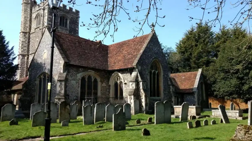
The church at Monken Hadley is particularly important. Historic England dates the west tower of St Mary the Virgin to about 1494. The building is Grade II* listed, which means it has particularly important architectural or historic interest.
The church occupies a prominent position beside Hadley Green and near historic roads. Barnet Council identifies St Mary the Virgin as the focal point of the Monken Hadley conservation area. Its location reflects the importance of churches as centres of medieval settlement.
St John the Baptist Church provides another direct connection with medieval Barnet. Barnet Council states that the first church on the site was built in the 11th century. A second church was built in the middle of the 15th century using money left by John Beauchamp.
The present building is largely the result of a major 19th-century reconstruction by William Butterfield. However, the north aisle is part of the 15th-century church. Barnet Council’s heritage material also identifies 15th-century remnants in the north wall.
These surviving sections are important because they represent physical medieval fabric rather than simply later references to medieval history.
Which medieval parts of St John the Baptist Church survive?
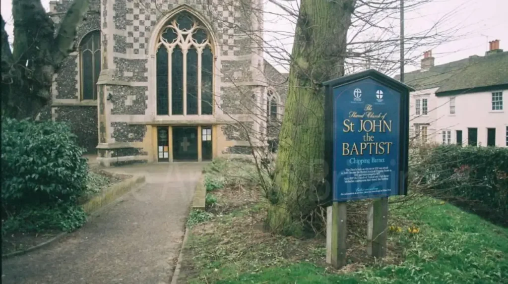
St John the Baptist Church in High Barnet contains surviving fabric from its medieval predecessor, particularly within the north aisle and north wall. The existing church was largely rebuilt in 1875, but these remnants connect the present building with medieval Barnet.
St John the Baptist stands at the junction of the High Street and Wood Street. This position is historically important because Barnet developed around the meeting of routes.
The church was originally associated with the older parish church at East Barnet. Barnet Council’s heritage walk describes St John’s as a 13th-century chapel of ease for St Mary the Virgin in East Barnet. A chapel of ease was a church building established to provide worship for people who lived too far from the main parish church.
The church was rebuilt during the 15th century. John Beauchamp provided funding for the medieval rebuilding. The 15th-century structure did not survive intact.
In 1875, the church underwent a major reconstruction designed by William Butterfield. Butterfield was a prominent Victorian Gothic Revival architect. The reconstruction created much of the appearance visible today.
The survival of the north aisle gives the church a direct architectural connection with the medieval period. The surviving fabric also demonstrates how historic buildings often contain several chronological layers.
This is an important feature for visitors examining Barnet’s heritage. Medieval architecture does not always survive as a complete building. It often appears as a wall, aisle, tower, doorway, roof element or reused structural section within a later building.
The church’s position also helps explain Barnet’s historic development. The High Street, Wood Street and church site formed part of a long-established movement corridor. Modern traffic now passes through the same broad urban area.
As you explore the modern site, you are crossing land with a deep heritage. Read about the full to understand its origins.
Does Barnet Market have medieval origins?
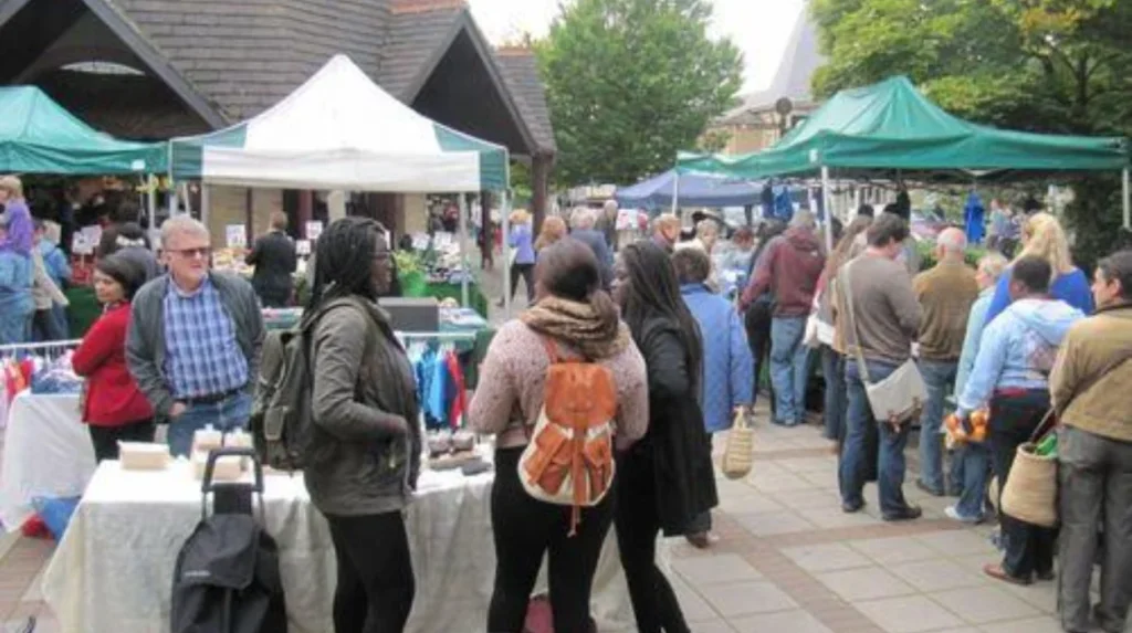
Barnet Market has medieval origins and has existed in different forms and locations since at least the 12th century. King John granted Barnet a market charter in August 1199, establishing a documented connection between the modern market tradition and medieval commercial activity.
Barnet Market is one of the clearest examples of a modern activity rooted in medieval Barnet.
Barnet Council records that the market existed in various forms and locations from at least the 12th century. A livestock market probably operated before King John granted the charter in August 1199.
A royal market charter was a legal grant allowing a market to operate on specified terms. Medieval markets were important commercial institutions. They brought together producers, traders, farmers, livestock sellers and consumers.
The original Barnet market was located around the junction where Wood Street divided from the High Street. This area remains one of the most historically significant parts of High Barnet.
The market later changed its operating arrangements and location. Records show that it was held on Mondays by 1588 and on Wednesdays by the 18th century.
The medieval market itself is not a surviving medieval structure. The importance lies in continuity of place, function and urban development.
Barnet’s position on the northward route from London strengthened the market’s commercial role. Livestock moved through the area, and traders used the town as a stopping point.
By the late Tudor period, Barnet Market had become a major livestock and meat-trading centre. London butchers travelled to Barnet to purchase cattle. The animals were often kept on nearby farms before being brought into London.
This commercial history helps explain why Barnet developed a busy high street. Medieval market activity established an economic focus that continued through later centuries.
Can the medieval street pattern still be seen in High Barnet?
High Barnet still preserves parts of its historic road structure, particularly around the junction of the High Street, Wood Street and St John the Baptist Church. The present roads reflect earlier routes that supported medieval movement, markets, churches and settlement.
Roads are among the most durable features of historic landscapes. Buildings can disappear, but route alignments often remain because later streets continue to follow established movement corridors.
High Barnet developed around the junction of important routes. Wood Street extends westwards from the area around St John the Baptist Church. The High Street follows the historic north-south corridor.
The Great North Road was one of the major routes connecting London with northern England. Its historical alignment through Barnet contributed to the settlement’s importance.
Barnet Council records that the road passed through the narrow section beside St John the Baptist Church known as the “Squeeze”. The restricted section was created by buildings and commercial activity along the road.
The original market occupied part of this area. Shops known as Middle Row stood in the road and formed part of the earlier market environment.
Middle Row was destroyed by fire in 1889. Its disappearance changed the appearance of the area, but the constrained road environment remains part of Barnet’s historic townscape.
The modern road network therefore contains layers from different periods. Medieval movement patterns influenced later roads. Georgian improvements altered the routes. Victorian rebuilding transformed buildings. Modern traffic management added further changes.
Visitors can still understand the basic medieval logic by examining the relationship between the church, High Street and Wood Street.
This makes High Barnet valuable as an urban heritage environment. The medieval evidence is not limited to individual buildings. It survives through the relationship between buildings, roads and commercial space.
What medieval features survive at Monken Hadley?
Monken Hadley preserves a historic village landscape containing St Mary the Virgin, Hadley Green, old roads, mature trees and settlement patterns associated with medieval development. The church provides the strongest surviving architectural evidence, while the surrounding landscape preserves the historic character.
Monken Hadley is one of Barnet’s most important areas for understanding medieval landscape development.
The name Hadley was recorded in a description of the boundary of the manor of Barnet in 1005. Barnet Council explains that the name refers to a heath-like clearing in woodland.
Hadley does not appear in the Domesday survey of 1086. Its later development was connected with religious and manorial activity.
In 1136, Geoffrey de Mandeville gave land to Walden Abbey in Essex. This monastic connection contributed to the name Monken Hadley. The name was in use by the 1170s.
The area contained a small hermitage associated with monks and a parish church. The medieval landscape therefore combined religious activity, settlement, woodland and open common land.
St Mary the Virgin remains the central historic building. Its late-15th-century west tower is particularly important. The church also contains later alterations, so visitors should distinguish medieval fabric from post-medieval and Victorian work.
Hadley Green provides another important element. It is an open area associated with the historic settlement and the Battle of Barnet.
The surrounding roads also retain historical significance. Barnet Council describes the church as being close to the crossing of ancient roads.
The conservation area designation protects the character of the historic landscape. Winding lanes, mature trees, open spaces and historic buildings create a setting that remains recognisable despite later development.
This makes Monken Hadley particularly useful for visitors interested in landscape history. The medieval character survives through a combination of structures, routes and open land rather than through one isolated monument.
Is the Battle of Barnet battlefield a surviving medieval feature?
The Battle of Barnet battlefield is a registered historic battlefield associated with the Wars of the Roses and the fighting of 14 April 1471. Parts of the historic landscape survive around Hadley Green, although the battlefield is not preserved as an untouched medieval site.
The Battle of Barnet was fought on Easter Day, 14 April 1471. It formed part of the Wars of the Roses, a series of dynastic conflicts involving the rival Houses of Lancaster and York.
King Edward IV commanded the Yorkist army. Richard Neville, Earl of Warwick, known as the Kingmaker, supported the Lancastrian cause.
The fighting took place north of High Barnet. The precise positions of the armies remain a subject of historical study, but Historic England identifies the registered battlefield around Barnet, South Mimms and Ridge.
The landscape was different in 1471. The area contained open ground, heathland, fields, hedges, marshy areas and routes used by people and livestock.
Historic England’s battlefield assessment identifies Hadley Green as the broad green associated with the battle. It also records historic landscape features including an ancient hedge and the route of an earlier road.
The battlefield was registered by Historic England in 1995. A registered battlefield is recognised for its special historic interest.
The site is not a conventional archaeological monument with walls or standing medieval buildings. Its significance lies in the relationship between terrain, roads, open land and documented military events.
The Battle of Barnet is particularly important because the Earl of Warwick was killed during the fighting. The battle strengthened Edward IV’s position during the Wars of the Roses.
Barnet Council identifies the surrounding area as London’s only registered battlefield site.
For visitors, Hadley Green offers an accessible way to understand this medieval event. The open landscape provides evidence of the type of terrain that influenced movement and military positioning.
What medieval landscape features remain around Hadley Green?
Hadley Green retains an open landscape linked to the medieval settlement and the 1471 battlefield. Historic roads, hedgerow features, changing ground levels and surviving open space help preserve the historical setting, although later development has altered parts of the original landscape.
The survival of Hadley Green is significant because open land often disappears faster than historic buildings.
Historic England’s battlefield assessment states that Hadley Green has remained largely intact since the 19th century, despite substantial development around High Barnet.
The modern landscape differs from the 15th-century environment. Housing, roads, recreation areas and other development now surround parts of the historic battlefield.
However, important elements remain visible.
The historic road network is one example. The A1000 broadly follows an earlier route through the area. Historic England identifies the earlier road alignment as an important component of the battlefield landscape.
An old hedge and associated bank-and-ditch feature also survive in the wider battlefield area. Historic England’s assessment identifies this as potentially ancient and connected with the historic landscape.
Ground levels are another important factor. Hadley Green occupies elevated land, while surrounding valleys and lower ground influenced movement across the battlefield.
These features demonstrate why battlefield heritage is different from conventional architectural heritage. A battlefield is often understood through landscape rather than through a single surviving structure.
The preservation of open space therefore has historical importance. It allows visitors to understand the relationship between roads, slopes, green space and settlement.
The wider Monken Hadley conservation area strengthens this context. Barnet Council identifies historic buildings, winding lanes, rough common land and groups of mature trees as reminders of earlier activity.
Is Hadley Highstone itself medieval?
Hadley Highstone is not a medieval monument. It is an 18th-century memorial erected around 1740 to commemorate the 1471 Battle of Barnet. Its importance lies in preserving the memory and location of a medieval battlefield within Barnet’s historic landscape.
Hadley Highstone is often associated with Barnet’s medieval history because it commemorates the Battle of Barnet.
The monument itself dates from about 1740. Historic England identifies it as a stone obelisk approximately 12 feet high.
Sir Jeremy Sambrook erected the monument to commemorate the battle between Edward IV and the Earl of Warwick on 14 April 1471.
The monument was originally positioned about 200 yards farther south. It was moved to its current location around 1840.
This distinction is important when identifying medieval features. Hadley Highstone is not surviving medieval fabric. It is a later heritage monument that preserves knowledge of a medieval event.
The monument therefore belongs to Barnet’s post-medieval heritage while directly representing medieval history.
Its position near the historic road junction adds further context. The surrounding landscape contains the church, green, roads and other historic features connected with Monken Hadley.
Visitors examining Hadley Highstone should therefore treat it as part of a layered heritage site.
The 15th-century battle, the medieval settlement and the 18th-century memorial belong to different historical periods. Together they demonstrate how later generations preserved and interpreted medieval events.
Explore More More Area Guide
How Barnet High Street Developed: Chipping Barnet History
Why Did Barnet Become an Important Market Town?
How can visitors identify Barnet’s medieval heritage today?
Visitors can identify Barnet’s medieval heritage by combining surviving church fabric with historic roads, market locations, Monken Hadley’s landscape and the registered Battle of Barnet site. High Barnet and Monken Hadley provide the strongest concentrations of accessible medieval historical evidence.
A practical heritage visit can begin around St John the Baptist Church in High Barnet.
The church provides direct architectural evidence through surviving 15th-century fabric. The surrounding junction also illustrates the historic relationship between church, road and market.
The High Street provides further context. The modern commercial centre occupies an area shaped by centuries of movement and trading activity.
The next stage is Monken Hadley. St Mary the Virgin provides one of Barnet’s clearest examples of surviving late-medieval architecture. The church stands beside Hadley Green, making it possible to examine building and landscape together.
Hadley Green is particularly important for understanding the Battle of Barnet. The registered battlefield extends beyond one small point, so the wider landscape should be considered rather than treating a single monument as the entire battlefield.
Hadley Highstone provides a later memorial reference to the battle.
Visitors interested in historical research can also use Barnet Council’s Local Studies and Archives resources. Historic England provides official records for listed buildings, conservation areas and the registered battlefield.
For digital nomads and business travellers, Barnet’s heritage sites also provide compact opportunities for cultural exploration between other activities. The main historic locations are concentrated enough to support a short walking-focused visit.
The most important principle is to distinguish original medieval fabric from later reconstruction and commemoration. St Mary the Virgin contains medieval fabric. St John the Baptist contains medieval remnants within a largely Victorian building. Hadley Highstone is an 18th-century memorial. Hadley Green is a historic landscape associated with a 15th-century battle.
Why do Barnet’s surviving medieval features matter today?
Barnet’s surviving medieval features show how religious buildings, markets, roads, settlements and landscapes shaped the modern district. Their continued preservation provides historical evidence that connects present-day High Barnet and Monken Hadley with developments recorded from the medieval period.
Barnet’s medieval heritage is important because it explains the structure of places that still function today.
The market tradition demonstrates economic continuity. The historic churches demonstrate the importance of parish organisation and religious institutions. The roads demonstrate long-term movement through north London. Hadley Green demonstrates the persistence of historic open landscapes.
These features also show that medieval heritage is not restricted to castles and fortified buildings.
Barnet developed largely through churches, markets, agricultural land, roads and settlements. Its surviving medieval evidence reflects that pattern.
The National Heritage List for England identifies ten Barnet entries associated with the medieval period between AD 1066 and AD 1540. This provides an official indication of the surviving designated heritage connected with the period.
The number is small compared with Barnet’s much larger collection of post-medieval and modern heritage. Historic England records hundreds of later entries across the borough.
That contrast explains why individual medieval survivals have particular importance.
Preserving medieval fabric also protects information about construction methods, materials, religious architecture and historical land use. Preserving landscapes protects evidence about settlement and movement.
Barnet’s heritage therefore has relevance beyond tourism. It supports local identity, conservation planning, archaeological research and public understanding of north London’s development.
The strongest surviving medieval evidence is concentrated around High Barnet, East Barnet and Monken Hadley. These locations provide a connected picture of how medieval religious, commercial and transport activity influenced the later urban landscape.
Barnet’s medieval heritage is therefore best understood as a network of surviving places rather than a single monument. St Mary the Virgin, the remnants of St John the Baptist, the historic market location, ancient routes, Hadley Green and the Battle of Barnet landscape each preserve a different part of that history.
For visitors exploring North London, these features provide a direct way to identify medieval history within the modern borough. The evidence remains visible in buildings, streets, green spaces and historic landmarks.
What medieval features can still be found in Barnet?
Barnet retains several important medieval features, including parts of St John the Baptist Church, the late-15th-century tower of St Mary the Virgin in Monken Hadley, historic road alignments, the medieval market site, Hadley Green and the Battle of Barnet battlefield.